You are here: Home > Network List > IU - Global Seismograph Network (GSN - IRIS/USGS) Stations List
> Station RSSD Black Hills, South Dakota, USA > Earthquake Result Viewer
RSSD Black Hills, South Dakota, USA - Earthquake Result Viewer

| Earthquake location: |
Bering Sea |
| Earthquake latitude/longitude: |
60.5/-177.9 |
| Earthquake time(UTC): |
2010/04/30 (120) 23:11:43 GMT |
| Earthquake Depth: |
12 km |
| Earthquake Magnitude: |
6.5 MW, 6.0 MB, 6.4 MW, 6.7 MS |
| Earthquake Catalog/Contributor: |
NEIC PDE/NEIC PDE-M |
|
| Network: |
IU Global Seismograph Network (GSN - IRIS/USGS) |
| Station: |
RSSD Black Hills, South Dakota, USA |
| Lat/Lon: |
44.12 N/104.04 W |
| Elevation: |
2090 m |
|
| Distance: |
45.4 deg |
| Az: |
76.229 deg |
| Baz: |
318.086 deg |
| Ray Param: |
0.071287304 |
| Estimated Moho Depth: |
15.25 km |
| Estimated Crust Vp/Vs: |
2.10 |
| Assumed Crust Vp: |
6.242 km/s |
| Estimated Crust Vs: |
2.976 km/s |
| Estimated Crust Poisson's Ratio: |
0.35 |
|
| Radial Match: |
95.99508 % |
| Radial Bump: |
315 |
| Transverse Match: |
79.93135 % |
| Transverse Bump: |
400 |
| SOD ConfigId: |
617450 |
| Insert Time: |
2013-10-01 04:32:30.809 +0000 |
| GWidth: |
2.5 |
| Max Bumps: |
400 |
| Tol: |
0.001 |
|
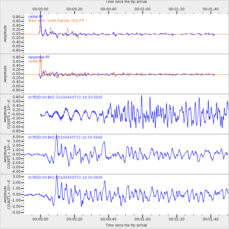
Signal To Noise
| Channel | StoN | STA | LTA |
| IU:RSSD:00:BHZ:20100430T23:19:30.669Z | 4.4585586 | 4.6418353E-7 | 1.0411067E-7 |
| IU:RSSD:00:BH1:20100430T23:19:30.669Z | 3.4880085 | 2.5743915E-7 | 7.3806916E-8 |
| IU:RSSD:00:BH2:20100430T23:19:30.669Z | 1.0147214 | 1.3967002E-7 | 1.3764371E-7 |
| Arrivals |
| Ps | 2.8 SECOND |
| PpPs | 7.2 SECOND |
| PsPs/PpSs | 10 SECOND |


