You are here: Home > Network List > II - Global Seismograph Network (GSN - IRIS/IDA) Stations List
> Station AAK Ala Archa, Kyrgyzstan > Earthquake Result Viewer
AAK Ala Archa, Kyrgyzstan - Earthquake Result Viewer
| Earthquake location: |
Banda Sea |
| Earthquake latitude/longitude: |
-6.9/129.2 |
| Earthquake time(UTC): |
1995/12/25 (359) 04:43:24 GMT |
| Earthquake Depth: |
150 km |
| Earthquake Magnitude: |
6.2 MB, 7.1 UNKNOWN, 7.1 MW |
| Earthquake Catalog/Contributor: |
WHDF/NEIC |
|
| Network: |
II Global Seismograph Network (GSN - IRIS/IDA) |
| Station: |
AAK Ala Archa, Kyrgyzstan |
| Lat/Lon: |
42.64 N/74.49 E |
| Elevation: |
1645 m |
|
| Distance: |
70.0 deg |
| Az: |
320.144 deg |
| Baz: |
120.435 deg |
| Ray Param: |
0.054885704 |
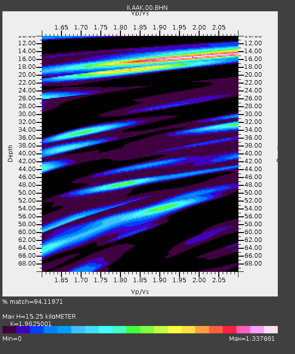
| Estimated Moho Depth: |
15.25 km |
| Estimated Crust Vp/Vs: |
1.98 |
| Assumed Crust Vp: |
6.306 km/s |
| Estimated Crust Vs: |
3.181 km/s |
| Estimated Crust Poisson's Ratio: |
0.33 |
|
| Radial Match: |
94.11971 % |
| Radial Bump: |
400 |
| Transverse Match: |
93.46098 % |
| Transverse Bump: |
400 |
| SOD ConfigId: |
6273 |
| Insert Time: |
2010-03-01 15:35:50.742 +0000 |
| GWidth: |
2.5 |
| Max Bumps: |
400 |
| Tol: |
0.001 |
|
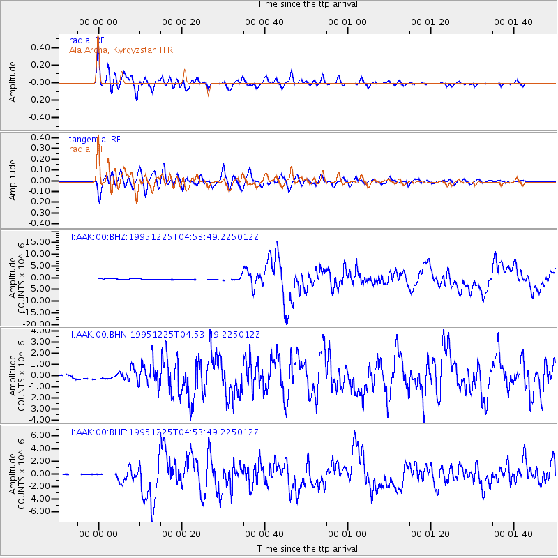
Signal To Noise
| Channel | StoN | STA | LTA |
| II:AAK:00:BHN:19951225T04:53:49.225012Z | 1.7850004 | 1.8851888E-7 | 1.0561279E-7 |
| II:AAK:00:BHE:19951225T04:53:49.225012Z | 2.232531 | 2.3684053E-7 | 1.060861E-7 |
| II:AAK:00:BHZ:19951225T04:53:49.225012Z | 6.1883183 | 8.396495E-7 | 1.3568298E-7 |
| Arrivals |
| Ps | 2.5 SECOND |
| PpPs | 7.0 SECOND |
| PsPs/PpSs | 9.4 SECOND |


