You are here: Home > Network List > II - Global Seismograph Network (GSN - IRIS/IDA) Stations List
> Station PALK Pallekele, Sri Lanka > Earthquake Result Viewer
PALK Pallekele, Sri Lanka - Earthquake Result Viewer
| Earthquake location: |
Southeast Of Honshu, Japan |
| Earthquake latitude/longitude: |
29.6/141.0 |
| Earthquake time(UTC): |
2010/05/03 (123) 10:27:45 GMT |
| Earthquake Depth: |
84 km |
| Earthquake Magnitude: |
6.1 MW, 6.1 MW, 6.2 MB |
| Earthquake Catalog/Contributor: |
NEIC PDE/NEIC PDE-M |
|
| Network: |
II Global Seismograph Network (GSN - IRIS/IDA) |
| Station: |
PALK Pallekele, Sri Lanka |
| Lat/Lon: |
7.27 N/80.70 E |
| Elevation: |
460 m |
|
| Distance: |
60.6 deg |
| Az: |
261.235 deg |
| Baz: |
60.141 deg |
| Ray Param: |
0.06117539 |
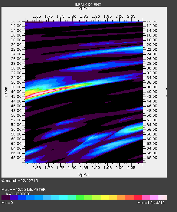
| Estimated Moho Depth: |
40.25 km |
| Estimated Crust Vp/Vs: |
1.67 |
| Assumed Crust Vp: |
6.545 km/s |
| Estimated Crust Vs: |
3.919 km/s |
| Estimated Crust Poisson's Ratio: |
0.22 |
|
| Radial Match: |
92.42713 % |
| Radial Bump: |
400 |
| Transverse Match: |
71.95616 % |
| Transverse Bump: |
400 |
| SOD ConfigId: |
617450 |
| Insert Time: |
2013-10-01 04:37:44.312 +0000 |
| GWidth: |
2.5 |
| Max Bumps: |
400 |
| Tol: |
0.001 |
|
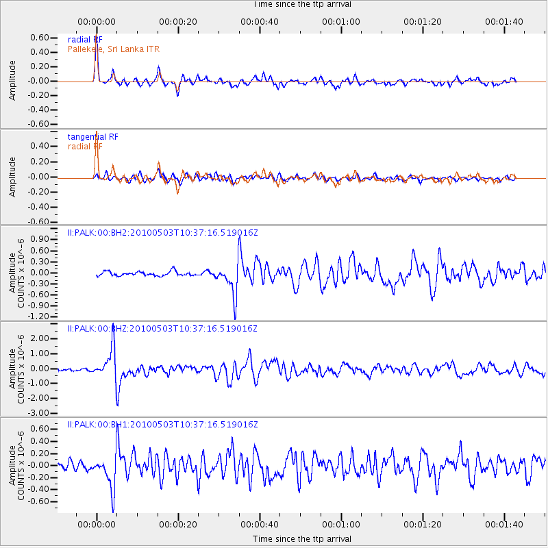
Signal To Noise
| Channel | StoN | STA | LTA |
| II:PALK:00:BHZ:20100503T10:37:16.519016Z | 15.037965 | 1.0898381E-6 | 7.247244E-8 |
| II:PALK:00:BH1:20100503T10:37:16.519016Z | 4.7247043 | 2.871241E-7 | 6.077081E-8 |
| II:PALK:00:BH2:20100503T10:37:16.519016Z | 7.7901754 | 4.4194596E-7 | 5.6731196E-8 |
| Arrivals |
| Ps | 4.3 SECOND |
| PpPs | 16 SECOND |
| PsPs/PpSs | 20 SECOND |


