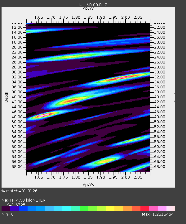
HNR Honiara, Solomon Islands - Earthquake Result Viewer
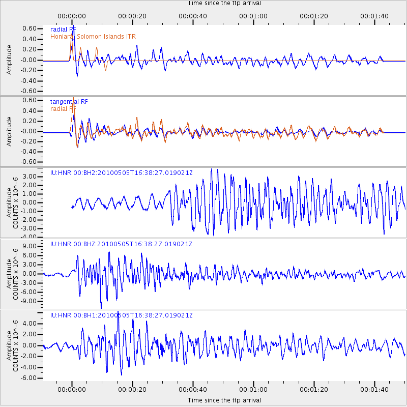
Earthquake location: Southern Sumatra, Indonesia
Earthquake latitude/longitude: -4.1/101.1
Earthquake time(UTC): 2010/05/05 (125) 16:29:03 GMT
Earthquake Depth: 27 km
Earthquake Magnitude: 6.5 MW, 5.9 MB, 6.4 MW, 6.6 MS
Earthquake Catalog/Contributor: NEIC PDE/NEIC PDE-M
Network: IU Global Seismograph Network (GSN - IRIS/USGS)
Station: HNR Honiara, Solomon Islands
Lat/Lon: 9.44 S/159.95 E
Elevation: 100 m
Distance: 58.6 deg
Az: 98.532 deg
Baz: 270.992 deg
Ray Param: 0.062676325
Estimated Moho Depth: 47.0 km
Estimated Crust Vp/Vs: 1.67
Assumed Crust Vp: 6.183 km/s
Estimated Crust Vs: 3.697 km/s
Estimated Crust Poisson's Ratio: 0.22
Radial Match: 91.0126 %
Radial Bump: 400
Transverse Match: 90.70623 %
Transverse Bump: 400
SOD ConfigId: 617450
Insert Time: 2013-10-01 04:45:19.799 +0000
GWidth: 2.5
Max Bumps: 400
Tol: 0.001

Signal To Noise

ChannelStoNSTALTA
IU:HNR:00:BHZ:20100505T16:38:27.019021Z8.4967473.0865476E-63.6326227E-7
IU:HNR:00:BH1:20100505T16:38:27.019021Z2.76797771.3573083E-64.90361E-7
IU:HNR:00:BH2:20100505T16:38:27.019021Z2.63467291.2041886E-64.570543E-7
Arrivals
Ps5.4 SECOND
PpPs19 SECOND
PsPs/PpSs25 SECOND