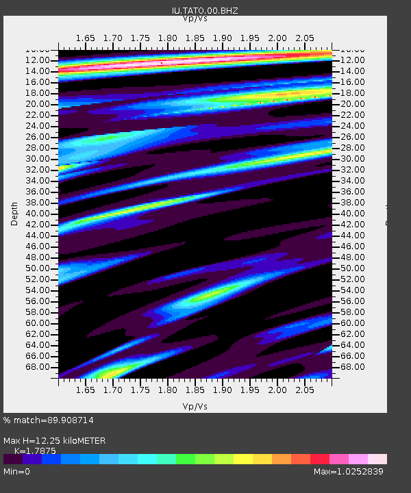
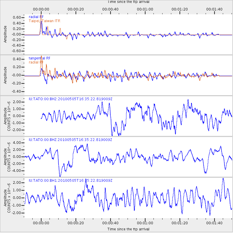
TATO Taipei, Taiwan - Earthquake Result Viewer

Earthquake location: Southern Sumatra, Indonesia
Earthquake latitude/longitude: -4.1/101.1
Earthquake time(UTC): 2010/05/05 (125) 16:29:03 GMT
Earthquake Depth: 27 km
Earthquake Magnitude: 6.5 MW, 5.9 MB, 6.4 MW, 6.6 MS
Earthquake Catalog/Contributor: NEIC PDE/NEIC PDE-M
Network: IU Global Seismograph Network (GSN - IRIS/USGS)
Station: TATO Taipei, Taiwan
Lat/Lon: 24.97 N/121.50 E
Elevation: 160 m
Distance: 35.0 deg
Az: 33.468 deg
Baz: 217.31 deg
Ray Param: 0.07740424
Estimated Moho Depth: 12.25 km
Estimated Crust Vp/Vs: 1.79
Assumed Crust Vp: 6.289 km/s
Estimated Crust Vs: 3.518 km/s
Estimated Crust Poisson's Ratio: 0.27
Radial Match: 89.908714 %
Radial Bump: 400
Transverse Match: 74.99378 %
Transverse Bump: 400
SOD ConfigId: 617450
Insert Time: 2013-10-01 04:45:25.642 +0000
GWidth: 2.5
Max Bumps: 400
Tol: 0.001

Signal To Noise

ChannelStoNSTALTA
IU:TATO:00:BHZ:20100505T16:35:22.819009Z4.51077651.2724067E-62.8208154E-7
IU:TATO:00:BH1:20100505T16:35:22.819009Z1.15662324.1699042E-73.6052398E-7
IU:TATO:00:BH2:20100505T16:35:22.819009Z1.87223527.7000504E-74.112758E-7
Arrivals
Ps1.6 SECOND
PpPs5.1 SECOND
PsPs/PpSs6.7 SECOND