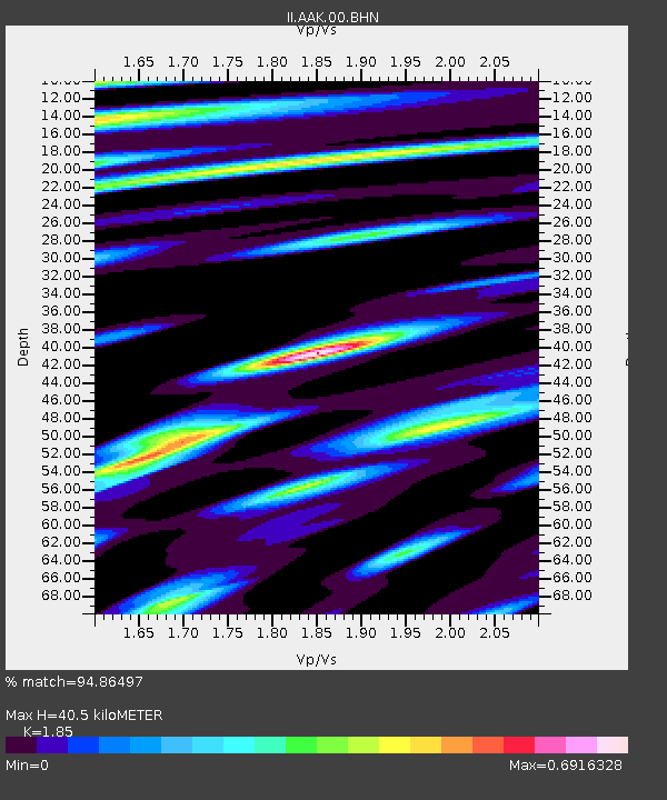
AAK Ala Archa, Kyrgyzstan - Earthquake Result Viewer
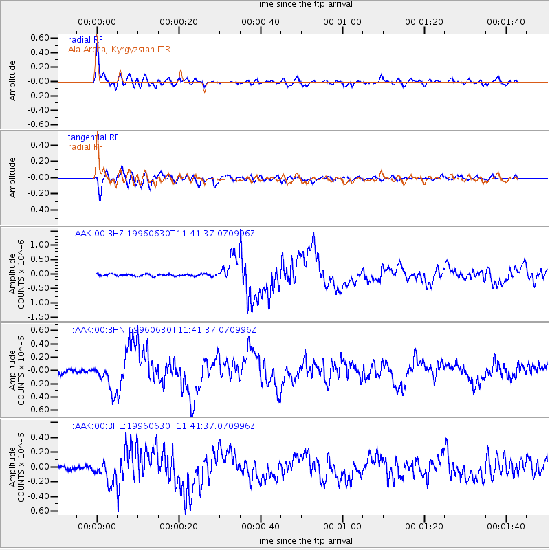
Earthquake location: Off East Coast Of Kamchatka
Earthquake latitude/longitude: 51.7/159.8
Earthquake time(UTC): 1996/06/30 (182) 11:32:35 GMT
Earthquake Depth: 33 km
Earthquake Magnitude: 5.5 MB, 5.9 MS, 6.1 UNKNOWN, 6.0 MW
Earthquake Catalog/Contributor: WHDF/NEIC
Network: II Global Seismograph Network (GSN - IRIS/IDA)
Station: AAK Ala Archa, Kyrgyzstan
Lat/Lon: 42.64 N/74.49 E
Elevation: 1645 m
Distance: 55.5 deg
Az: 296.87 deg
Baz: 48.756 deg
Ray Param: 0.06467222
Estimated Moho Depth: 40.5 km
Estimated Crust Vp/Vs: 1.85
Assumed Crust Vp: 6.306 km/s
Estimated Crust Vs: 3.409 km/s
Estimated Crust Poisson's Ratio: 0.29
Radial Match: 94.86497 %
Radial Bump: 400
Transverse Match: 89.52262 %
Transverse Bump: 400
SOD ConfigId: 6273
Insert Time: 2010-03-01 15:36:13.405 +0000
GWidth: 2.5
Max Bumps: 400
Tol: 0.001

Signal To Noise

ChannelStoNSTALTA
II:AAK:00:BHN:19960630T11:41:37.070996Z4.9737522.2170987E-74.457598E-8
II:AAK:00:BHE:19960630T11:41:37.070996Z6.08700041.4852073E-72.4399657E-8
II:AAK:00:BHZ:19960630T11:41:37.070996Z15.7186124.600819E-72.926988E-8
Arrivals
Ps5.7 SECOND
PpPs17 SECOND
PsPs/PpSs23 SECOND