You are here: Home > Network List > IU - Global Seismograph Network (GSN - IRIS/USGS) Stations List
> Station HNR Honiara, Solomon Islands > Earthquake Result Viewer
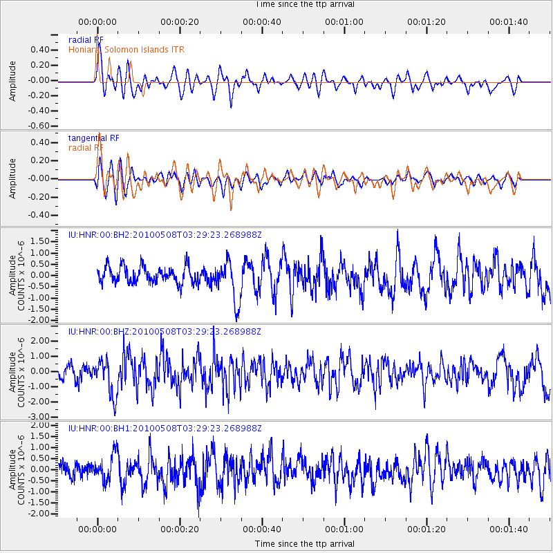
HNR Honiara, Solomon Islands - Earthquake Result Viewer
*The percent match for this event was below the threshold and hence no stack was calculated.
| Earthquake location: |
Sumbawa Region, Indonesia |
| Earthquake latitude/longitude: |
-8.1/118.3 |
| Earthquake time(UTC): |
2010/05/08 (128) 03:22:09 GMT |
| Earthquake Depth: |
12 km |
| Earthquake Magnitude: |
5.9 MW, 5.5 MS, 5.6 MB, 5.8 MW |
| Earthquake Catalog/Contributor: |
NEIC PDE/NEIC PDE-M |
|
| Network: |
IU Global Seismograph Network (GSN - IRIS/USGS) |
| Station: |
HNR Honiara, Solomon Islands |
| Lat/Lon: |
9.44 S/159.95 E |
| Elevation: |
100 m |
|
| Distance: |
41.2 deg |
| Az: |
95.084 deg |
| Baz: |
268.488 deg |
| Ray Param: |
$rayparam |
*The percent match for this event was below the threshold and hence was not used in the summary stack. |
|
| Radial Match: |
60.269306 % |
| Radial Bump: |
400 |
| Transverse Match: |
72.53214 % |
| Transverse Bump: |
400 |
| SOD ConfigId: |
617450 |
| Insert Time: |
2013-10-01 04:55:27.341 +0000 |
| GWidth: |
2.5 |
| Max Bumps: |
400 |
| Tol: |
0.001 |
|
Signal To Noise
| Channel | StoN | STA | LTA |
| IU:HNR:00:BHZ:20100508T03:29:23.268988Z | 2.6340492 | 1.2072111E-6 | 4.5831E-7 |
| IU:HNR:00:BH1:20100508T03:29:23.268988Z | 2.0725746 | 6.1921173E-7 | 2.987645E-7 |
| IU:HNR:00:BH2:20100508T03:29:23.268988Z | 2.614461 | 9.535687E-7 | 3.647286E-7 |
| Arrivals |
| Ps | |
| PpPs | |
| PsPs/PpSs | |


