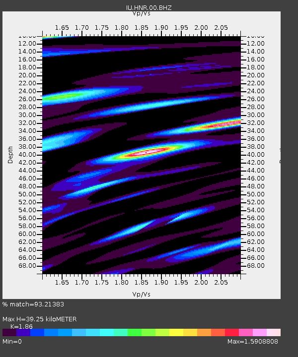
HNR Honiara, Solomon Islands - Earthquake Result Viewer
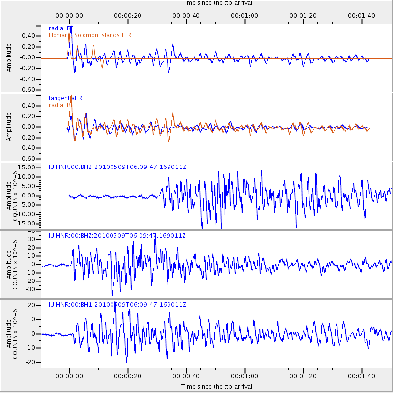
Earthquake location: Northern Sumatra, Indonesia
Earthquake latitude/longitude: 3.7/96.0
Earthquake time(UTC): 2010/05/09 (129) 05:59:41 GMT
Earthquake Depth: 38 km
Earthquake Magnitude: 7.2 MW, 6.6 MB, 7.2 MW, 7.3 MS
Earthquake Catalog/Contributor: NEIC PDE/NEIC PDE-M
Network: IU Global Seismograph Network (GSN - IRIS/USGS)
Station: HNR Honiara, Solomon Islands
Lat/Lon: 9.44 S/159.95 E
Elevation: 100 m
Distance: 65.0 deg
Az: 102.146 deg
Baz: 278.597 deg
Ray Param: 0.058470756
Estimated Moho Depth: 39.25 km
Estimated Crust Vp/Vs: 1.86
Assumed Crust Vp: 6.183 km/s
Estimated Crust Vs: 3.324 km/s
Estimated Crust Poisson's Ratio: 0.30
Radial Match: 93.21383 %
Radial Bump: 400
Transverse Match: 91.10348 %
Transverse Bump: 400
SOD ConfigId: 617450
Insert Time: 2013-10-01 05:00:35.090 +0000
GWidth: 2.5
Max Bumps: 400
Tol: 0.001

Signal To Noise

ChannelStoNSTALTA
IU:HNR:00:BHZ:20100509T06:09:47.169011Z22.8209971.00189145E-54.3902176E-7
IU:HNR:00:BH1:20100509T06:09:47.169011Z13.4892554.1871176E-63.104039E-7
IU:HNR:00:BH2:20100509T06:09:47.169011Z8.1964853.8185417E-64.658756E-7
Arrivals
Ps5.7 SECOND
PpPs18 SECOND
PsPs/PpSs23 SECOND