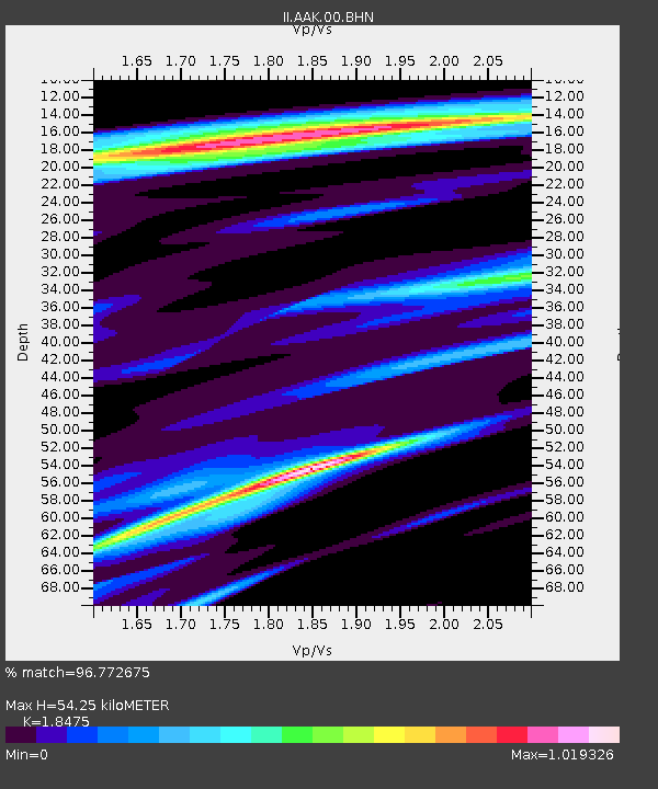
AAK Ala Archa, Kyrgyzstan - Earthquake Result Viewer

Earthquake location: Minahassa Peninsula, Sulawesi
Earthquake latitude/longitude: 0.7/120.0
Earthquake time(UTC): 1996/01/01 (001) 08:05:11 GMT
Earthquake Depth: 33 km
Earthquake Magnitude: 6.2 MB, 7.7 MS, 7.8 UNKNOWN, 7.8 MW
Earthquake Catalog/Contributor: WHDF/NEIC
Network: II Global Seismograph Network (GSN - IRIS/IDA)
Station: AAK Ala Archa, Kyrgyzstan
Lat/Lon: 42.64 N/74.49 E
Elevation: 1645 m
Distance: 58.3 deg
Az: 321.787 deg
Baz: 123.046 deg
Ray Param: 0.06288908
Estimated Moho Depth: 54.25 km
Estimated Crust Vp/Vs: 1.85
Assumed Crust Vp: 6.306 km/s
Estimated Crust Vs: 3.413 km/s
Estimated Crust Poisson's Ratio: 0.29
Radial Match: 96.772675 %
Radial Bump: 400
Transverse Match: 91.384315 %
Transverse Bump: 400
SOD ConfigId: 6273
Insert Time: 2010-03-01 15:36:34.431 +0000
GWidth: 2.5
Max Bumps: 400
Tol: 0.001

Signal To Noise

ChannelStoNSTALTA
II:AAK:00:BHN:19960101T08:14:32.608008Z2.63195324.7065166E-71.7882219E-7
II:AAK:00:BHE:19960101T08:14:32.608008Z2.6110781.0190271E-63.9027063E-7
II:AAK:00:BHZ:19960101T08:14:32.608008Z3.92077922.4123767E-66.1527993E-7
Arrivals
Ps7.6 SECOND
PpPs23 SECOND
PsPs/PpSs31 SECOND