You are here: Home > Network List > IU - Global Seismograph Network (GSN - IRIS/USGS) Stations List
> Station RSSD Black Hills, South Dakota, USA > Earthquake Result Viewer
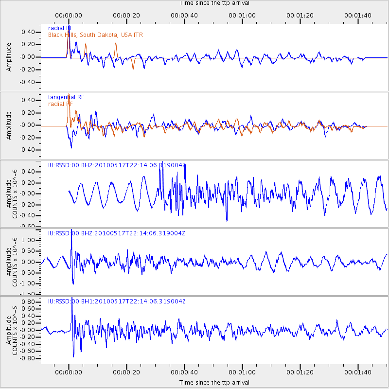
RSSD Black Hills, South Dakota, USA - Earthquake Result Viewer
*The percent match for this event was below the threshold and hence no stack was calculated.
| Earthquake location: |
Kuril Islands |
| Earthquake latitude/longitude: |
46.3/152.0 |
| Earthquake time(UTC): |
2010/05/17 (137) 22:03:47 GMT |
| Earthquake Depth: |
73 km |
| Earthquake Magnitude: |
5.7 MB, 5.3 MW |
| Earthquake Catalog/Contributor: |
WHDF/NEIC |
|
| Network: |
IU Global Seismograph Network (GSN - IRIS/USGS) |
| Station: |
RSSD Black Hills, South Dakota, USA |
| Lat/Lon: |
44.12 N/104.04 W |
| Elevation: |
2090 m |
|
| Distance: |
67.7 deg |
| Az: |
49.067 deg |
| Baz: |
313.332 deg |
| Ray Param: |
$rayparam |
*The percent match for this event was below the threshold and hence was not used in the summary stack. |
|
| Radial Match: |
56.221233 % |
| Radial Bump: |
400 |
| Transverse Match: |
83.58112 % |
| Transverse Bump: |
400 |
| SOD ConfigId: |
617450 |
| Insert Time: |
2013-10-01 05:09:02.756 +0000 |
| GWidth: |
2.5 |
| Max Bumps: |
400 |
| Tol: |
0.001 |
|
Signal To Noise
| Channel | StoN | STA | LTA |
| IU:RSSD:00:BHZ:20100517T22:14:06.319004Z | 3.210909 | 4.7054397E-7 | 1.4654542E-7 |
| IU:RSSD:00:BH1:20100517T22:14:06.319004Z | 3.888888 | 3.2666662E-7 | 8.4000014E-8 |
| IU:RSSD:00:BH2:20100517T22:14:06.319004Z | 1.4208586 | 2.1078688E-7 | 1.4835177E-7 |
| Arrivals |
| Ps | |
| PpPs | |
| PsPs/PpSs | |


