You are here: Home > Network List > US - United States National Seismic Network Stations List
> Station KSU1 Kansas State University--Konza Prairie, Kansas, USA > Earthquake Result Viewer
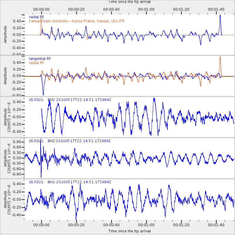
KSU1 Kansas State University--Konza Prairie, Kansas, USA - Earthquake Result Viewer
*The percent match for this event was below the threshold and hence no stack was calculated.
| Earthquake location: |
Kuril Islands |
| Earthquake latitude/longitude: |
46.3/152.0 |
| Earthquake time(UTC): |
2010/05/17 (137) 22:03:47 GMT |
| Earthquake Depth: |
73 km |
| Earthquake Magnitude: |
5.7 MB, 5.3 MW |
| Earthquake Catalog/Contributor: |
WHDF/NEIC |
|
| Network: |
US United States National Seismic Network |
| Station: |
KSU1 Kansas State University--Konza Prairie, Kansas, USA |
| Lat/Lon: |
39.10 N/96.61 W |
| Elevation: |
347 m |
|
| Distance: |
75.2 deg |
| Az: |
48.551 deg |
| Baz: |
318.089 deg |
| Ray Param: |
$rayparam |
*The percent match for this event was below the threshold and hence was not used in the summary stack. |
|
| Radial Match: |
47.036133 % |
| Radial Bump: |
400 |
| Transverse Match: |
79.43301 % |
| Transverse Bump: |
400 |
| SOD ConfigId: |
617450 |
| Insert Time: |
2013-10-01 05:09:17.976 +0000 |
| GWidth: |
2.5 |
| Max Bumps: |
400 |
| Tol: |
0.001 |
|
Signal To Noise
| Channel | StoN | STA | LTA |
| US:KSU1: :BHZ:20100517T22:14:51.173984Z | 2.2894664 | 3.698372E-7 | 1.6153861E-7 |
| US:KSU1: :BH1:20100517T22:14:51.173984Z | 0.557244 | 1.0148543E-7 | 1.8212029E-7 |
| US:KSU1: :BH2:20100517T22:14:51.173984Z | 0.8407223 | 1.7298142E-7 | 2.0575334E-7 |
| Arrivals |
| Ps | |
| PpPs | |
| PsPs/PpSs | |


