You are here: Home > Network List > CU - Caribbean Network (USGS) Stations List
> Station BBGH Gun Hill, Barbados > Earthquake Result Viewer
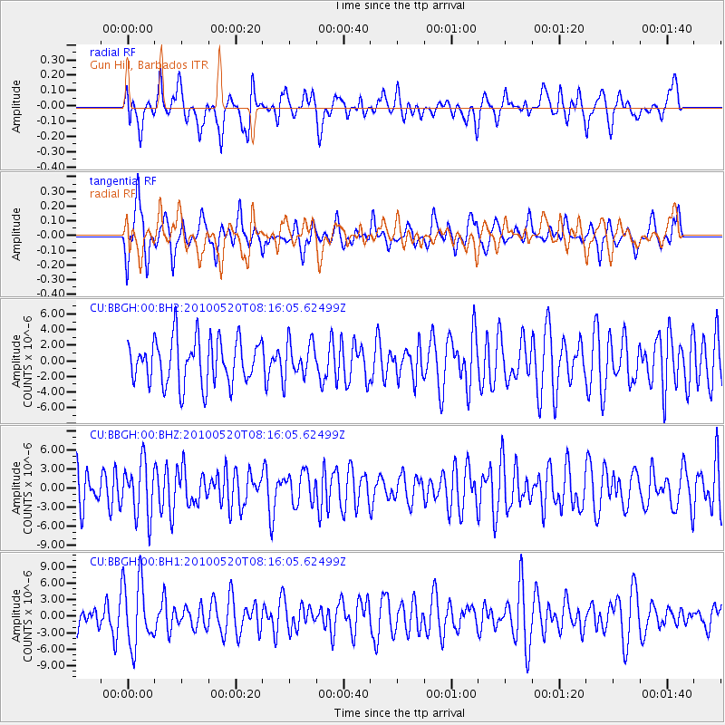
BBGH Gun Hill, Barbados - Earthquake Result Viewer
*The percent match for this event was below the threshold and hence no stack was calculated.
| Earthquake location: |
Southeast Of Easter Island |
| Earthquake latitude/longitude: |
-39.1/-92.2 |
| Earthquake time(UTC): |
2010/05/20 (140) 08:06:28 GMT |
| Earthquake Depth: |
10 km |
| Earthquake Magnitude: |
5.5 MB, 5.6 MS, 5.9 MW, 5.9 MW |
| Earthquake Catalog/Contributor: |
WHDF/NEIC |
|
| Network: |
CU Caribbean Network (USGS) |
| Station: |
BBGH Gun Hill, Barbados |
| Lat/Lon: |
13.14 N/59.56 W |
| Elevation: |
180 m |
|
| Distance: |
60.2 deg |
| Az: |
37.219 deg |
| Baz: |
208.908 deg |
| Ray Param: |
$rayparam |
*The percent match for this event was below the threshold and hence was not used in the summary stack. |
|
| Radial Match: |
49.57216 % |
| Radial Bump: |
400 |
| Transverse Match: |
59.869255 % |
| Transverse Bump: |
400 |
| SOD ConfigId: |
617450 |
| Insert Time: |
2013-10-01 05:16:33.405 +0000 |
| GWidth: |
2.5 |
| Max Bumps: |
400 |
| Tol: |
0.001 |
|
Signal To Noise
| Channel | StoN | STA | LTA |
| CU:BBGH:00:BHZ:20100520T08:16:05.62499Z | 1.3441917 | 4.2649417E-6 | 3.1728673E-6 |
| CU:BBGH:00:BH1:20100520T08:16:05.62499Z | 2.1363862 | 5.970403E-6 | 2.794627E-6 |
| CU:BBGH:00:BH2:20100520T08:16:05.62499Z | 0.8026355 | 2.3069151E-6 | 2.8741754E-6 |
| Arrivals |
| Ps | |
| PpPs | |
| PsPs/PpSs | |


