You are here: Home > Network List > IU - Global Seismograph Network (GSN - IRIS/USGS) Stations List
> Station HNR Honiara, Solomon Islands > Earthquake Result Viewer
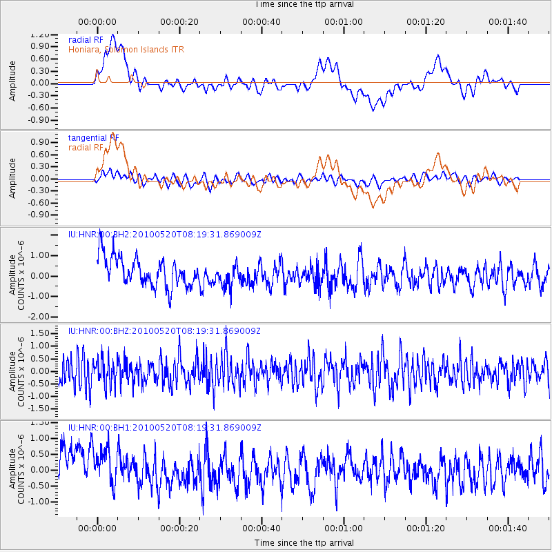
HNR Honiara, Solomon Islands - Earthquake Result Viewer
*The percent match for this event was below the threshold and hence no stack was calculated.
| Earthquake location: |
Southeast Of Easter Island |
| Earthquake latitude/longitude: |
-39.1/-92.2 |
| Earthquake time(UTC): |
2010/05/20 (140) 08:06:28 GMT |
| Earthquake Depth: |
10 km |
| Earthquake Magnitude: |
5.5 MB, 5.6 MS, 5.9 MW, 5.9 MW |
| Earthquake Catalog/Contributor: |
WHDF/NEIC |
|
| Network: |
IU Global Seismograph Network (GSN - IRIS/USGS) |
| Station: |
HNR Honiara, Solomon Islands |
| Lat/Lon: |
9.44 S/159.95 E |
| Elevation: |
100 m |
|
| Distance: |
97.7 deg |
| Az: |
251.339 deg |
| Baz: |
131.619 deg |
| Ray Param: |
$rayparam |
*The percent match for this event was below the threshold and hence was not used in the summary stack. |
|
| Radial Match: |
27.749598 % |
| Radial Bump: |
400 |
| Transverse Match: |
42.436592 % |
| Transverse Bump: |
400 |
| SOD ConfigId: |
617450 |
| Insert Time: |
2013-10-01 05:16:52.370 +0000 |
| GWidth: |
2.5 |
| Max Bumps: |
400 |
| Tol: |
0.001 |
|
Signal To Noise
| Channel | StoN | STA | LTA |
| IU:HNR:00:BHZ:20100520T08:19:31.869009Z | 0.98317385 | 5.012024E-7 | 5.0978E-7 |
| IU:HNR:00:BH1:20100520T08:19:31.869009Z | 0.7175791 | 8.7526956E-7 | 1.2197535E-6 |
| IU:HNR:00:BH2:20100520T08:19:31.869009Z | 0.80103105 | 5.675032E-7 | 7.084659E-7 |
| Arrivals |
| Ps | |
| PpPs | |
| PsPs/PpSs | |


