You are here: Home > Network List > IU - Global Seismograph Network (GSN - IRIS/USGS) Stations List
> Station ANMO Albuquerque, New Mexico, USA > Earthquake Result Viewer
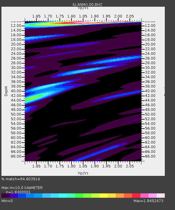
ANMO Albuquerque, New Mexico, USA - Earthquake Result Viewer
| Earthquake location: |
Central Peru |
| Earthquake latitude/longitude: |
-13.9/-74.4 |
| Earthquake time(UTC): |
2010/05/23 (143) 22:46:52 GMT |
| Earthquake Depth: |
101 km |
| Earthquake Magnitude: |
6.1 MW, 6.1 MW, 6.3 MB |
| Earthquake Catalog/Contributor: |
NEIC PDE/NEIC PDE-M |
|
| Network: |
IU Global Seismograph Network (GSN - IRIS/USGS) |
| Station: |
ANMO Albuquerque, New Mexico, USA |
| Lat/Lon: |
34.95 N/106.46 W |
| Elevation: |
1820 m |
|
| Distance: |
57.4 deg |
| Az: |
328.771 deg |
| Baz: |
142.208 deg |
| Ray Param: |
0.06324452 |
| Estimated Moho Depth: |
10.0 km |
| Estimated Crust Vp/Vs: |
1.93 |
| Assumed Crust Vp: |
6.502 km/s |
| Estimated Crust Vs: |
3.369 km/s |
| Estimated Crust Poisson's Ratio: |
0.32 |
|
| Radial Match: |
94.603516 % |
| Radial Bump: |
365 |
| Transverse Match: |
64.70217 % |
| Transverse Bump: |
400 |
| SOD ConfigId: |
617450 |
| Insert Time: |
2013-10-01 05:26:02.654 +0000 |
| GWidth: |
2.5 |
| Max Bumps: |
400 |
| Tol: |
0.001 |
|

Signal To Noise
| Channel | StoN | STA | LTA |
| IU:ANMO:00:BHZ:20100523T22:55:59.068982Z | 12.514005 | 1.6375785E-6 | 1.3085968E-7 |
| IU:ANMO:00:BH1:20100523T22:55:59.068982Z | 18.388626 | 8.7921796E-7 | 4.781314E-8 |
| IU:ANMO:00:BH2:20100523T22:55:59.068982Z | 1.4613522 | 2.2388045E-7 | 1.5320089E-7 |
| Arrivals |
| Ps | 1.5 SECOND |
| PpPs | 4.3 SECOND |
| PsPs/PpSs | 5.8 SECOND |


