You are here: Home > Network List > US - United States National Seismic Network Stations List
> Station ECSD EROS Data Center, Sioux Falls, South Dakota, USA > Earthquake Result Viewer
ECSD EROS Data Center, Sioux Falls, South Dakota, USA - Earthquake Result Viewer
| Earthquake location: |
Central Peru |
| Earthquake latitude/longitude: |
-13.9/-74.4 |
| Earthquake time(UTC): |
2010/05/23 (143) 22:46:52 GMT |
| Earthquake Depth: |
101 km |
| Earthquake Magnitude: |
6.1 MW, 6.1 MW, 6.3 MB |
| Earthquake Catalog/Contributor: |
NEIC PDE/NEIC PDE-M |
|
| Network: |
US United States National Seismic Network |
| Station: |
ECSD EROS Data Center, Sioux Falls, South Dakota, USA |
| Lat/Lon: |
43.73 N/96.60 W |
| Elevation: |
469 m |
|
| Distance: |
60.9 deg |
| Az: |
341.688 deg |
| Baz: |
155.112 deg |
| Ray Param: |
0.060954448 |
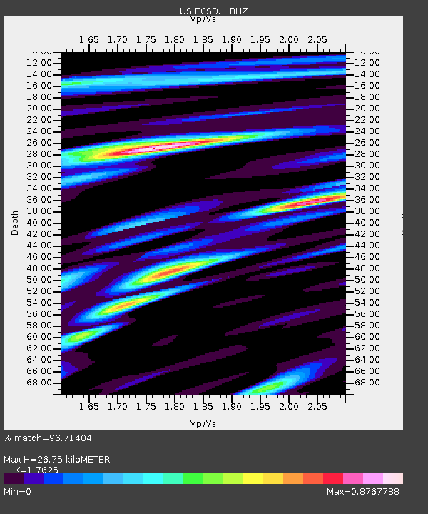
| Estimated Moho Depth: |
26.75 km |
| Estimated Crust Vp/Vs: |
1.76 |
| Assumed Crust Vp: |
6.498 km/s |
| Estimated Crust Vs: |
3.687 km/s |
| Estimated Crust Poisson's Ratio: |
0.26 |
|
| Radial Match: |
96.71404 % |
| Radial Bump: |
344 |
| Transverse Match: |
84.47811 % |
| Transverse Bump: |
400 |
| SOD ConfigId: |
617450 |
| Insert Time: |
2013-10-01 05:26:53.208 +0000 |
| GWidth: |
2.5 |
| Max Bumps: |
400 |
| Tol: |
0.001 |
|

Signal To Noise
| Channel | StoN | STA | LTA |
| US:ECSD: :BHZ:20100523T22:56:23.300Z | 31.005316 | 2.400211E-6 | 7.7412885E-8 |
| US:ECSD: :BH1:20100523T22:56:23.300Z | 17.595438 | 8.305078E-7 | 4.720018E-8 |
| US:ECSD: :BH2:20100523T22:56:23.300Z | 16.74816 | 1.2075947E-6 | 7.210313E-8 |
| Arrivals |
| Ps | 3.3 SECOND |
| PpPs | 11 SECOND |
| PsPs/PpSs | 14 SECOND |


