You are here: Home > Network List > US - United States National Seismic Network Stations List
> Station KSU1 Kansas State University--Konza Prairie, Kansas, USA > Earthquake Result Viewer
KSU1 Kansas State University--Konza Prairie, Kansas, USA - Earthquake Result Viewer
| Earthquake location: |
Central Peru |
| Earthquake latitude/longitude: |
-13.9/-74.4 |
| Earthquake time(UTC): |
2010/05/23 (143) 22:46:52 GMT |
| Earthquake Depth: |
101 km |
| Earthquake Magnitude: |
6.1 MW, 6.1 MW, 6.3 MB |
| Earthquake Catalog/Contributor: |
NEIC PDE/NEIC PDE-M |
|
| Network: |
US United States National Seismic Network |
| Station: |
KSU1 Kansas State University--Konza Prairie, Kansas, USA |
| Lat/Lon: |
39.10 N/96.61 W |
| Elevation: |
347 m |
|
| Distance: |
56.7 deg |
| Az: |
339.353 deg |
| Baz: |
153.895 deg |
| Ray Param: |
0.06366463 |
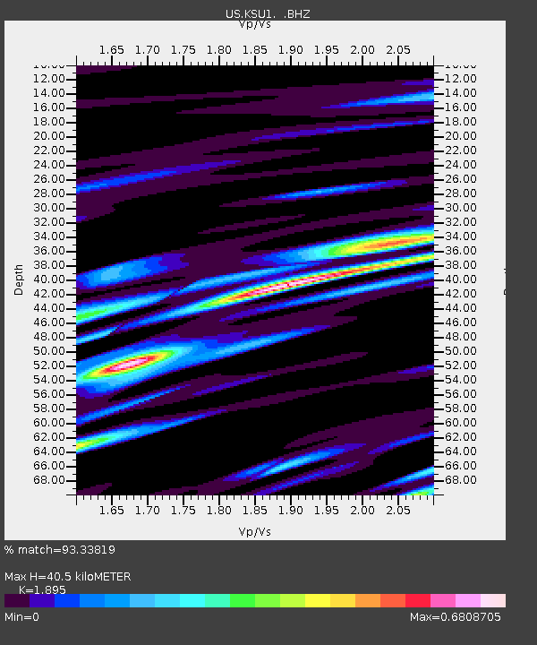
| Estimated Moho Depth: |
40.5 km |
| Estimated Crust Vp/Vs: |
1.89 |
| Assumed Crust Vp: |
6.483 km/s |
| Estimated Crust Vs: |
3.421 km/s |
| Estimated Crust Poisson's Ratio: |
0.31 |
|
| Radial Match: |
93.33819 % |
| Radial Bump: |
400 |
| Transverse Match: |
82.97517 % |
| Transverse Bump: |
400 |
| SOD ConfigId: |
617450 |
| Insert Time: |
2013-10-01 05:26:53.515 +0000 |
| GWidth: |
2.5 |
| Max Bumps: |
400 |
| Tol: |
0.001 |
|
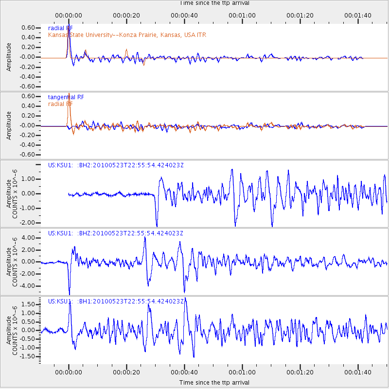
Signal To Noise
| Channel | StoN | STA | LTA |
| US:KSU1: :BHZ:20100523T22:55:54.424023Z | 16.160109 | 1.8653959E-6 | 1.1543215E-7 |
| US:KSU1: :BH1:20100523T22:55:54.424023Z | 6.012506 | 6.862695E-7 | 1.1414034E-7 |
| US:KSU1: :BH2:20100523T22:55:54.424023Z | 13.7142515 | 8.963747E-7 | 6.5360815E-8 |
| Arrivals |
| Ps | 5.9 SECOND |
| PpPs | 17 SECOND |
| PsPs/PpSs | 23 SECOND |


