You are here: Home > Network List > IU - Global Seismograph Network (GSN - IRIS/USGS) Stations List
> Station RSSD Black Hills, South Dakota, USA > Earthquake Result Viewer
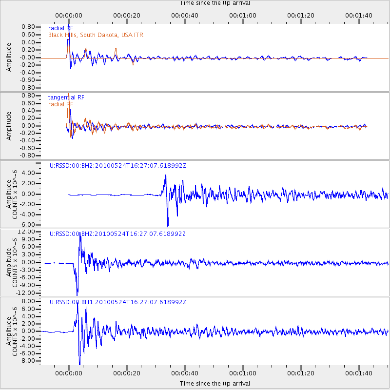
RSSD Black Hills, South Dakota, USA - Earthquake Result Viewer
*The percent match for this event was below the threshold and hence no stack was calculated.
| Earthquake location: |
Western Brazil |
| Earthquake latitude/longitude: |
-8.1/-71.6 |
| Earthquake time(UTC): |
2010/05/24 (144) 16:18:29 GMT |
| Earthquake Depth: |
581 km |
| Earthquake Magnitude: |
6.5 MW, 6.0 MB, 6.5 MW |
| Earthquake Catalog/Contributor: |
NEIC PDE/NEIC PDE-M |
|
| Network: |
IU Global Seismograph Network (GSN - IRIS/USGS) |
| Station: |
RSSD Black Hills, South Dakota, USA |
| Lat/Lon: |
44.12 N/104.04 W |
| Elevation: |
2090 m |
|
| Distance: |
59.7 deg |
| Az: |
333.388 deg |
| Baz: |
141.984 deg |
| Ray Param: |
$rayparam |
*The percent match for this event was below the threshold and hence was not used in the summary stack. |
|
| Radial Match: |
96.7727 % |
| Radial Bump: |
370 |
| Transverse Match: |
88.90739 % |
| Transverse Bump: |
400 |
| SOD ConfigId: |
617450 |
| Insert Time: |
2013-10-01 05:28:24.412 +0000 |
| GWidth: |
2.5 |
| Max Bumps: |
400 |
| Tol: |
0.001 |
|
Signal To Noise
| Channel | StoN | STA | LTA |
| IU:RSSD:00:BHZ:20100524T16:27:07.618992Z | 76.104065 | 5.2214714E-6 | 6.860962E-8 |
| IU:RSSD:00:BH1:20100524T16:27:07.618992Z | 41.155693 | 3.465587E-6 | 8.420675E-8 |
| IU:RSSD:00:BH2:20100524T16:27:07.618992Z | 38.102337 | 1.9615277E-6 | 5.1480512E-8 |
| Arrivals |
| Ps | |
| PpPs | |
| PsPs/PpSs | |


