You are here: Home > Network List > US - United States National Seismic Network Stations List
> Station KSU1 Kansas State University--Konza Prairie, Kansas, USA > Earthquake Result Viewer
KSU1 Kansas State University--Konza Prairie, Kansas, USA - Earthquake Result Viewer
| Earthquake location: |
Western Brazil |
| Earthquake latitude/longitude: |
-8.1/-71.6 |
| Earthquake time(UTC): |
2010/05/24 (144) 16:18:29 GMT |
| Earthquake Depth: |
581 km |
| Earthquake Magnitude: |
6.5 MW, 6.0 MB, 6.5 MW |
| Earthquake Catalog/Contributor: |
NEIC PDE/NEIC PDE-M |
|
| Network: |
US United States National Seismic Network |
| Station: |
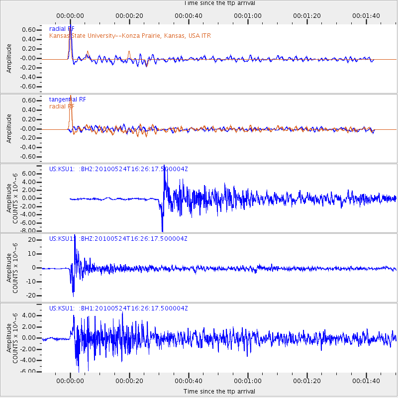
KSU1 Kansas State University--Konza Prairie, Kansas, USA |
| Lat/Lon: |
39.10 N/96.61 W |
| Elevation: |
347 m |
|
| Distance: |
52.4 deg |
| Az: |
335.426 deg |
| Baz: |
148.047 deg |
| Ray Param: |
0.064178586 |
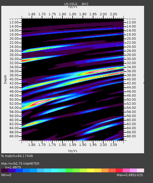
| Estimated Moho Depth: |
50.75 km |
| Estimated Crust Vp/Vs: |
1.70 |
| Assumed Crust Vp: |
6.483 km/s |
| Estimated Crust Vs: |
3.819 km/s |
| Estimated Crust Poisson's Ratio: |
0.23 |
|
| Radial Match: |
94.17449 % |
| Radial Bump: |
400 |
| Transverse Match: |
84.53769 % |
| Transverse Bump: |
400 |
| SOD ConfigId: |
617450 |
| Insert Time: |
2013-10-01 05:28:39.677 +0000 |
| GWidth: |
2.5 |
| Max Bumps: |
400 |
| Tol: |
0.001 |
|
Signal To Noise
| Channel | StoN | STA | LTA |
| US:KSU1: :BHZ:20100524T16:26:17.500004Z | 65.49997 | 7.739487E-6 | 1.18160166E-7 |
| US:KSU1: :BH1:20100524T16:26:17.500004Z | 17.336266 | 1.943449E-6 | 1.1210309E-7 |
| US:KSU1: :BH2:20100524T16:26:17.500004Z | 23.31409 | 3.012955E-6 | 1.2923321E-7 |
| Arrivals |
| Ps | 5.8 SECOND |
| PpPs | 20 SECOND |
| PsPs/PpSs | 26 SECOND |


