You are here: Home > Network List > IU - Global Seismograph Network (GSN - IRIS/USGS) Stations List
> Station HNR Honiara, Solomon Islands > Earthquake Result Viewer
HNR Honiara, Solomon Islands - Earthquake Result Viewer
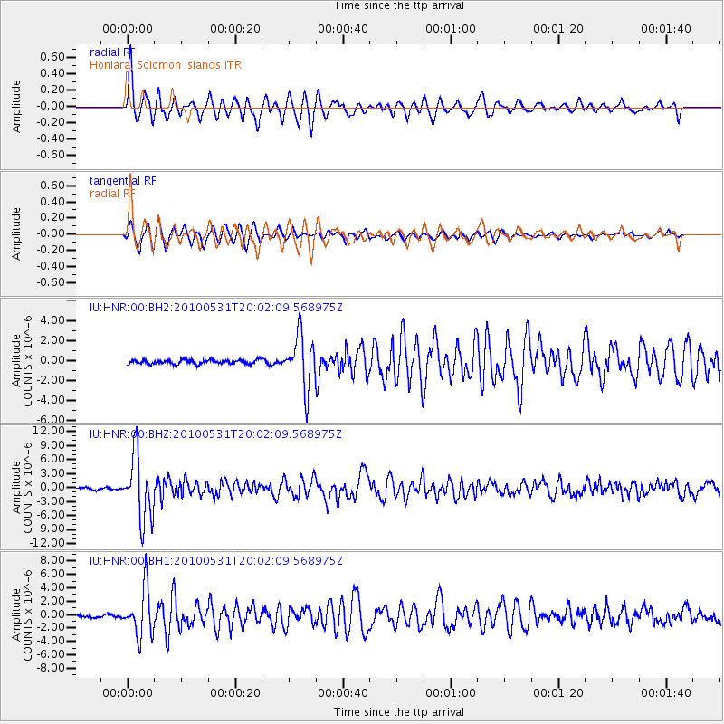
| Earthquake location: |
Andaman Islands, India Region |
| Earthquake latitude/longitude: |
11.1/93.5 |
| Earthquake time(UTC): |
2010/05/31 (151) 19:51:45 GMT |
| Earthquake Depth: |
112 km |
| Earthquake Magnitude: |
6.1 MB, 6.5 MW, 6.4 MW |
| Earthquake Catalog/Contributor: |
WHDF/NEIC |
|
| Network: |
IU Global Seismograph Network (GSN - IRIS/USGS) |
| Station: |
HNR Honiara, Solomon Islands |
| Lat/Lon: |
9.44 S/159.95 E |
| Elevation: |
100 m |
|
| Distance: |
69.2 deg |
| Az: |
104.588 deg |
| Baz: |
285.708 deg |
| Ray Param: |
0.055519268 |
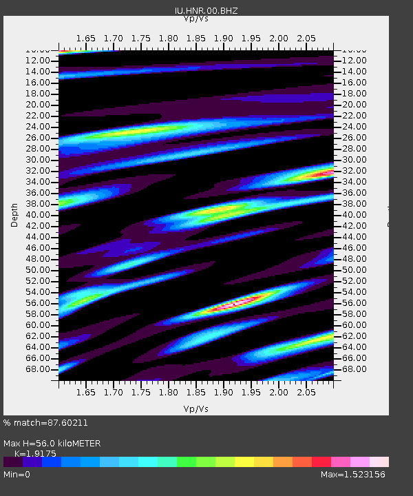
| Estimated Moho Depth: |
56.0 km |
| Estimated Crust Vp/Vs: |
1.92 |
| Assumed Crust Vp: |
6.183 km/s |
| Estimated Crust Vs: |
3.224 km/s |
| Estimated Crust Poisson's Ratio: |
0.31 |
|
| Radial Match: |
87.60211 % |
| Radial Bump: |
400 |
| Transverse Match: |
89.03371 % |
| Transverse Bump: |
368 |
| SOD ConfigId: |
617450 |
| Insert Time: |
2013-10-01 05:46:30.105 +0000 |
| GWidth: |
2.5 |
| Max Bumps: |
400 |
| Tol: |
0.001 |
|
Signal To Noise
| Channel | StoN | STA | LTA |
| IU:HNR:00:BHZ:20100531T20:02:09.568975Z | 38.488716 | 6.9274865E-6 | 1.7998747E-7 |
| IU:HNR:00:BH1:20100531T20:02:09.568975Z | 18.394148 | 3.5715132E-6 | 1.9416574E-7 |
| IU:HNR:00:BH2:20100531T20:02:09.568975Z | 12.752026 | 2.5986528E-6 | 2.0378354E-7 |
| Arrivals |
| Ps | 8.6 SECOND |
| PpPs | 26 SECOND |
| PsPs/PpSs | 34 SECOND |


