You are here: Home > Network List > IU - Global Seismograph Network (GSN - IRIS/USGS) Stations List
> Station HNR Honiara, Solomon Islands > Earthquake Result Viewer
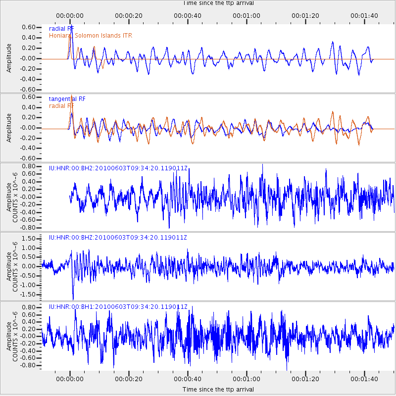
HNR Honiara, Solomon Islands - Earthquake Result Viewer
*The percent match for this event was below the threshold and hence no stack was calculated.
| Earthquake location: |
Northern Sumatra, Indonesia |
| Earthquake latitude/longitude: |
4.8/95.8 |
| Earthquake time(UTC): |
2010/06/03 (154) 09:24:15 GMT |
| Earthquake Depth: |
74 km |
| Earthquake Magnitude: |
5.5 MB |
| Earthquake Catalog/Contributor: |
NEIC PDE/NEIC PDE-M |
|
| Network: |
IU Global Seismograph Network (GSN - IRIS/USGS) |
| Station: |
HNR Honiara, Solomon Islands |
| Lat/Lon: |
9.44 S/159.95 E |
| Elevation: |
100 m |
|
| Distance: |
65.5 deg |
| Az: |
102.566 deg |
| Baz: |
279.643 deg |
| Ray Param: |
$rayparam |
*The percent match for this event was below the threshold and hence was not used in the summary stack. |
|
| Radial Match: |
58.257973 % |
| Radial Bump: |
400 |
| Transverse Match: |
62.11003 % |
| Transverse Bump: |
400 |
| SOD ConfigId: |
617450 |
| Insert Time: |
2013-10-01 06:02:04.984 +0000 |
| GWidth: |
2.5 |
| Max Bumps: |
400 |
| Tol: |
0.001 |
|
Signal To Noise
| Channel | StoN | STA | LTA |
| IU:HNR:00:BHZ:20100603T09:34:20.119011Z | 3.9365323 | 6.3186997E-7 | 1.6051436E-7 |
| IU:HNR:00:BH1:20100603T09:34:20.119011Z | 1.4956368 | 2.80657E-7 | 1.8765049E-7 |
| IU:HNR:00:BH2:20100603T09:34:20.119011Z | 1.3368627 | 2.7138987E-7 | 2.0300504E-7 |
| Arrivals |
| Ps | |
| PpPs | |
| PsPs/PpSs | |


