You are here: Home > Network List > IU - Global Seismograph Network (GSN - IRIS/USGS) Stations List
> Station HNR Honiara, Solomon Islands > Earthquake Result Viewer
HNR Honiara, Solomon Islands - Earthquake Result Viewer
| Earthquake location: |
Bonin Islands, Japan Region |
| Earthquake latitude/longitude: |
26.7/142.5 |
| Earthquake time(UTC): |
2010/06/11 (162) 16:37:48 GMT |
| Earthquake Depth: |
7.0 km |
| Earthquake Magnitude: |
5.6 MW, 5.5 MB, 5.7 MW |
| Earthquake Catalog/Contributor: |
NEIC PDE/NEIC PDE-M |
|
| Network: |
IU Global Seismograph Network (GSN - IRIS/USGS) |
| Station: |
HNR Honiara, Solomon Islands |
| Lat/Lon: |
9.44 S/159.95 E |
| Elevation: |
100 m |
|
| Distance: |
39.7 deg |
| Az: |
152.42 deg |
| Baz: |
335.176 deg |
| Ray Param: |
0.07483776 |
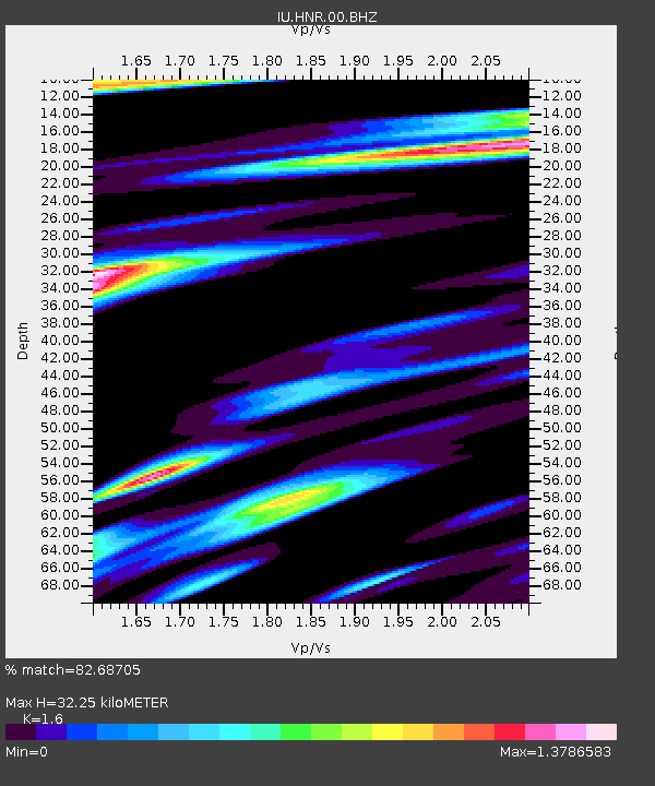
| Estimated Moho Depth: |
32.25 km |
| Estimated Crust Vp/Vs: |
1.60 |
| Assumed Crust Vp: |
6.183 km/s |
| Estimated Crust Vs: |
3.864 km/s |
| Estimated Crust Poisson's Ratio: |
0.18 |
|
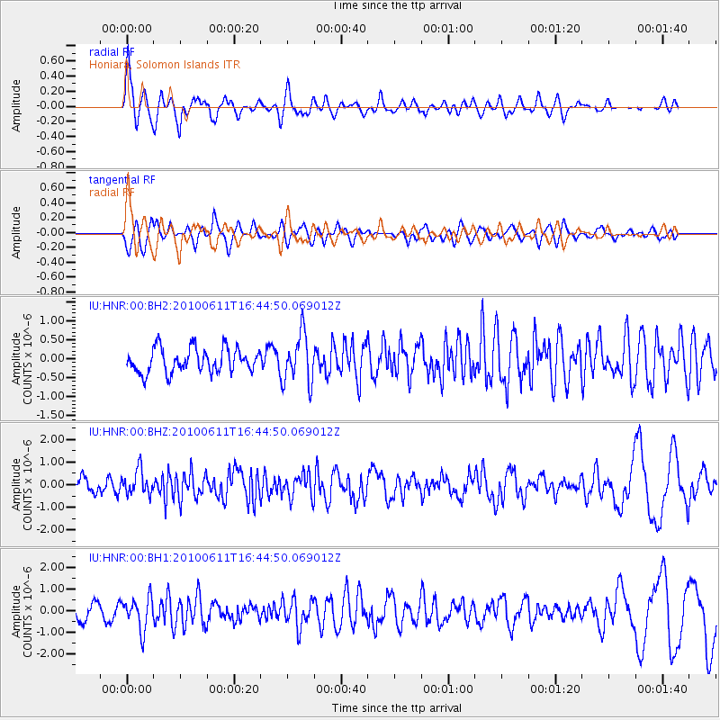
| Radial Match: |
82.68705 % |
| Radial Bump: |
392 |
| Transverse Match: |
73.01806 % |
| Transverse Bump: |
400 |
| SOD ConfigId: |
617450 |
| Insert Time: |
2013-10-01 06:14:05.491 +0000 |
| GWidth: |
2.5 |
| Max Bumps: |
400 |
| Tol: |
0.001 |
|
Signal To Noise
| Channel | StoN | STA | LTA |
| IU:HNR:00:BHZ:20100611T16:44:50.069012Z | 1.7209816 | 5.5930707E-7 | 3.2499307E-7 |
| IU:HNR:00:BH1:20100611T16:44:50.069012Z | 2.311677 | 7.353175E-7 | 3.1808833E-7 |
| IU:HNR:00:BH2:20100611T16:44:50.069012Z | 2.0647662 | 6.560633E-7 | 3.1774218E-7 |
| Arrivals |
| Ps | 3.4 SECOND |
| PpPs | 13 SECOND |
| PsPs/PpSs | 16 SECOND |


