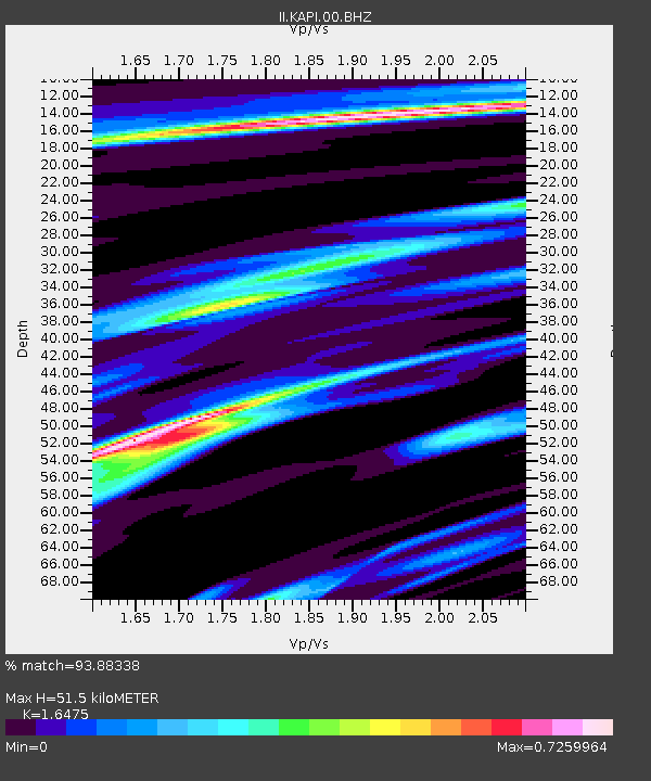
KAPI Kappang, Sulawesi, Indonesia - Earthquake Result Viewer

Earthquake location: Nicobar Islands, India Region
Earthquake latitude/longitude: 7.9/91.9
Earthquake time(UTC): 2010/06/12 (163) 19:26:50 GMT
Earthquake Depth: 35 km
Earthquake Magnitude: 7.5 MW, 7.0 MB, 7.4 MW, 7.5 MS
Earthquake Catalog/Contributor: NEIC PDE/NEIC PDE-M
Network: II Global Seismograph Network (GSN - IRIS/IDA)
Station: KAPI Kappang, Sulawesi, Indonesia
Lat/Lon: 5.01 S/119.75 E
Elevation: 300 m
Distance: 30.6 deg
Az: 113.903 deg
Baz: 294.613 deg
Ray Param: 0.07926551
Estimated Moho Depth: 51.5 km
Estimated Crust Vp/Vs: 1.65
Assumed Crust Vp: 6.343 km/s
Estimated Crust Vs: 3.85 km/s
Estimated Crust Poisson's Ratio: 0.21
Radial Match: 93.88338 %
Radial Bump: 277
Transverse Match: 72.64755 %
Transverse Bump: 400
SOD ConfigId: 617450
Insert Time: 2013-10-01 06:19:19.668 +0000
GWidth: 2.5
Max Bumps: 400
Tol: 0.001

Signal To Noise

ChannelStoNSTALTA
II:KAPI:00:BHZ:20100612T19:32:30.569009Z68.576981.4825952E-52.161943E-7
II:KAPI:00:BH1:20100612T19:32:30.569009Z36.0389863.4747047E-69.641517E-8
II:KAPI:00:BH2:20100612T19:32:30.569009Z42.4697231.0032336E-52.3622326E-7
Arrivals
Ps5.7 SECOND
PpPs20 SECOND
PsPs/PpSs25 SECOND