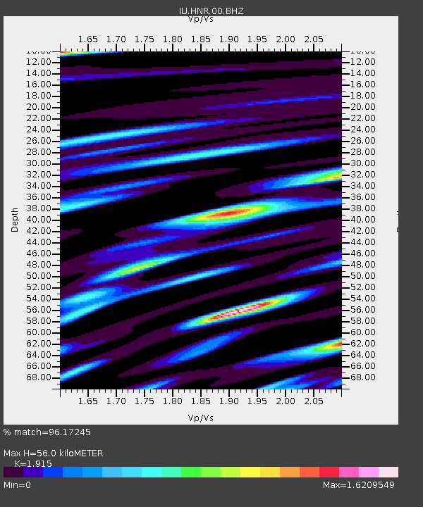
HNR Honiara, Solomon Islands - Earthquake Result Viewer
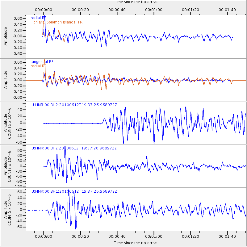
Earthquake location: Nicobar Islands, India Region
Earthquake latitude/longitude: 7.9/91.9
Earthquake time(UTC): 2010/06/12 (163) 19:26:50 GMT
Earthquake Depth: 35 km
Earthquake Magnitude: 7.5 MW, 7.0 MB, 7.4 MW, 7.5 MS
Earthquake Catalog/Contributor: NEIC PDE/NEIC PDE-M
Network: IU Global Seismograph Network (GSN - IRIS/USGS)
Station: HNR Honiara, Solomon Islands
Lat/Lon: 9.44 S/159.95 E
Elevation: 100 m
Distance: 69.9 deg
Az: 103.03 deg
Baz: 281.974 deg
Ray Param: 0.055289626
Estimated Moho Depth: 56.0 km
Estimated Crust Vp/Vs: 1.91
Assumed Crust Vp: 6.183 km/s
Estimated Crust Vs: 3.229 km/s
Estimated Crust Poisson's Ratio: 0.31
Radial Match: 96.17245 %
Radial Bump: 400
Transverse Match: 95.28794 %
Transverse Bump: 400
SOD ConfigId: 617450
Insert Time: 2013-10-01 06:19:39.884 +0000
GWidth: 2.5
Max Bumps: 400
Tol: 0.001

Signal To Noise

ChannelStoNSTALTA
IU:HNR:00:BHZ:20100612T19:37:26.968972Z76.657512.2949172E-52.993728E-7
IU:HNR:00:BH1:20100612T19:37:26.968972Z26.822556.336406E-62.362343E-7
IU:HNR:00:BH2:20100612T19:37:26.968972Z22.2706077.066956E-63.1732213E-7
Arrivals
Ps8.6 SECOND
PpPs26 SECOND
PsPs/PpSs34 SECOND