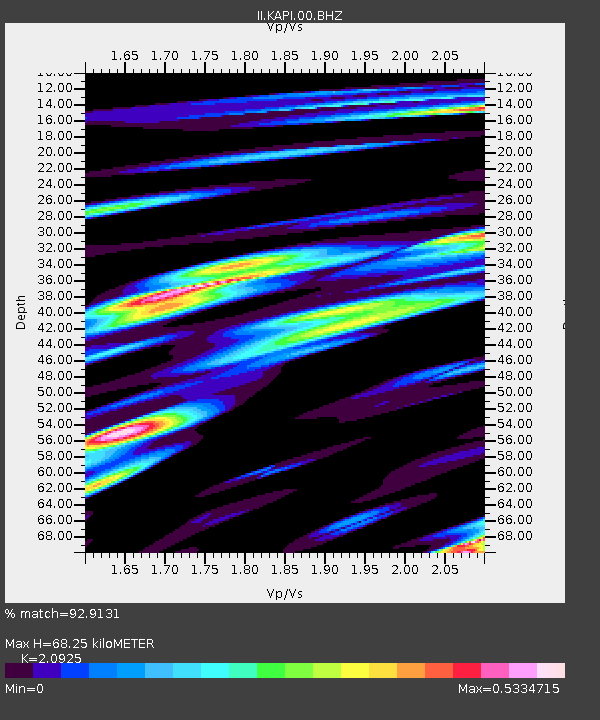
KAPI Kappang, Sulawesi, Indonesia - Earthquake Result Viewer

Earthquake location: Near East Coast Of Honshu, Japan
Earthquake latitude/longitude: 37.4/141.6
Earthquake time(UTC): 2010/06/13 (164) 03:32:57 GMT
Earthquake Depth: 27 km
Earthquake Magnitude: 5.9 MW, 5.6 MS, 5.8 MW, 6.3 MB
Earthquake Catalog/Contributor: NEIC PDE/NEIC PDE-M
Network: II Global Seismograph Network (GSN - IRIS/IDA)
Station: KAPI Kappang, Sulawesi, Indonesia
Lat/Lon: 5.01 S/119.75 E
Elevation: 300 m
Distance: 46.8 deg
Az: 210.585 deg
Baz: 24.01 deg
Ray Param: 0.07034025
Estimated Moho Depth: 68.25 km
Estimated Crust Vp/Vs: 2.09
Assumed Crust Vp: 6.343 km/s
Estimated Crust Vs: 3.031 km/s
Estimated Crust Poisson's Ratio: 0.35
Radial Match: 92.9131 %
Radial Bump: 400
Transverse Match: 85.936 %
Transverse Bump: 400
SOD ConfigId: 617450
Insert Time: 2013-10-01 06:21:31.922 +0000
GWidth: 2.5
Max Bumps: 400
Tol: 0.001

Signal To Noise

ChannelStoNSTALTA
II:KAPI:00:BHZ:20100613T03:40:54.018992Z17.9534592.0909895E-61.1646723E-7
II:KAPI:00:BH1:20100613T03:40:54.018992Z16.3504181.2987601E-67.943284E-8
II:KAPI:00:BH2:20100613T03:40:54.018992Z8.0943476.826047E-78.433104E-8
Arrivals
Ps12 SECOND
PpPs32 SECOND
PsPs/PpSs44 SECOND