You are here: Home > Network List > IU - Global Seismograph Network (GSN - IRIS/USGS) Stations List
> Station RSSD Black Hills, South Dakota, USA > Earthquake Result Viewer
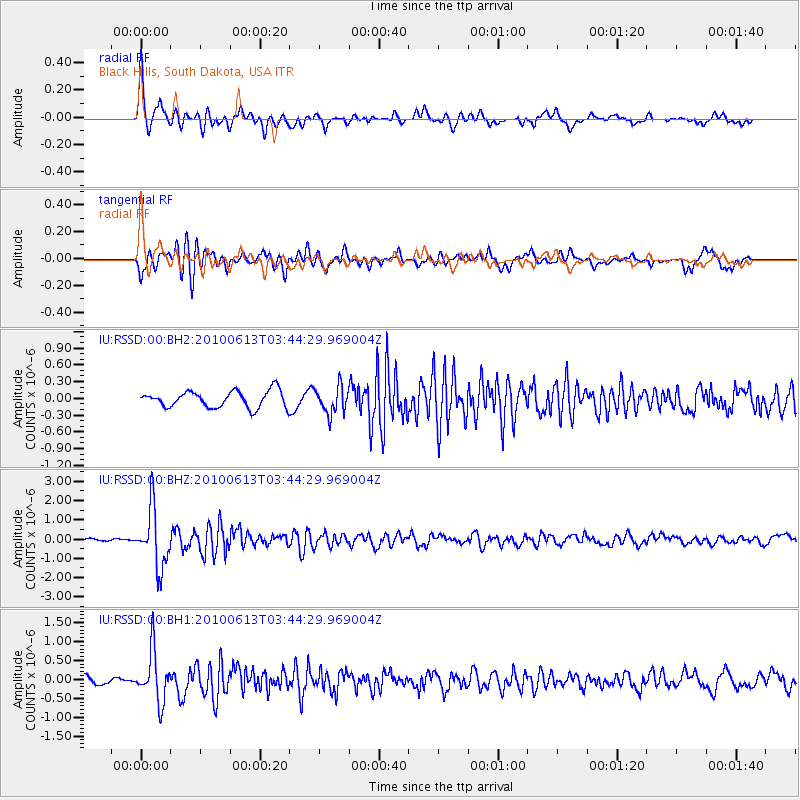
RSSD Black Hills, South Dakota, USA - Earthquake Result Viewer
*The percent match for this event was below the threshold and hence no stack was calculated.
| Earthquake location: |
Near East Coast Of Honshu, Japan |
| Earthquake latitude/longitude: |
37.4/141.6 |
| Earthquake time(UTC): |
2010/06/13 (164) 03:32:57 GMT |
| Earthquake Depth: |
27 km |
| Earthquake Magnitude: |
5.9 MW, 5.6 MS, 5.8 MW, 6.3 MB |
| Earthquake Catalog/Contributor: |
NEIC PDE/NEIC PDE-M |
|
| Network: |
IU Global Seismograph Network (GSN - IRIS/USGS) |
| Station: |
RSSD Black Hills, South Dakota, USA |
| Lat/Lon: |
44.12 N/104.04 W |
| Elevation: |
2090 m |
|
| Distance: |
79.5 deg |
| Az: |
41.87 deg |
| Baz: |
312.412 deg |
| Ray Param: |
$rayparam |
*The percent match for this event was below the threshold and hence was not used in the summary stack. |
|
| Radial Match: |
78.4623 % |
| Radial Bump: |
363 |
| Transverse Match: |
75.895386 % |
| Transverse Bump: |
400 |
| SOD ConfigId: |
617450 |
| Insert Time: |
2013-10-01 06:22:02.626 +0000 |
| GWidth: |
2.5 |
| Max Bumps: |
400 |
| Tol: |
0.001 |
|
Signal To Noise
| Channel | StoN | STA | LTA |
| IU:RSSD:00:BHZ:20100613T03:44:29.969004Z | 13.01636 | 1.5263112E-6 | 1.1726098E-7 |
| IU:RSSD:00:BH1:20100613T03:44:29.969004Z | 5.18778 | 6.6443295E-7 | 1.2807655E-7 |
| IU:RSSD:00:BH2:20100613T03:44:29.969004Z | 1.6300551 | 2.4101968E-7 | 1.4785984E-7 |
| Arrivals |
| Ps | |
| PpPs | |
| PsPs/PpSs | |


