You are here: Home > Network List > KZ - Kazakhstan Network Stations List
> Station KUR21 Cross-array, Kurchatov, Kazakstan > Earthquake Result Viewer
KUR21 Cross-array, Kurchatov, Kazakstan - Earthquake Result Viewer
| Earthquake location: |
Kuril Islands |
| Earthquake latitude/longitude: |
44.4/148.7 |
| Earthquake time(UTC): |
2010/06/18 (169) 02:23:05 GMT |
| Earthquake Depth: |
28 km |
| Earthquake Magnitude: |
6.2 MW, 5.9 MB, 6.0 MS, 6.1 MW |
| Earthquake Catalog/Contributor: |
NEIC PDE/NEIC PDE-M |
|
| Network: |
KZ Kazakhstan Network |
| Station: |
KUR21 Cross-array, Kurchatov, Kazakstan |
| Lat/Lon: |
50.62 N/78.53 E |
| Elevation: |
200 m |
|
| Distance: |
46.1 deg |
| Az: |
303.81 deg |
| Baz: |
69.112 deg |
| Ray Param: |
0.07077677 |
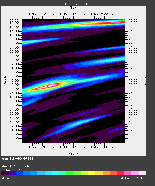
| Estimated Moho Depth: |
42.5 km |
| Estimated Crust Vp/Vs: |
1.72 |
| Assumed Crust Vp: |
6.552 km/s |
| Estimated Crust Vs: |
3.804 km/s |
| Estimated Crust Poisson's Ratio: |
0.25 |
|
| Radial Match: |
95.69488 % |
| Radial Bump: |
400 |
| Transverse Match: |
92.54379 % |
| Transverse Bump: |
400 |
| SOD ConfigId: |
617450 |
| Insert Time: |
2013-10-01 06:34:28.387 +0000 |
| GWidth: |
2.5 |
| Max Bumps: |
400 |
| Tol: |
0.001 |
|

Signal To Noise
| Channel | StoN | STA | LTA |
| KZ:KUR21: :BHZ:20100618T02:30:56.824995Z | 32.01871 | 1.483194E-6 | 4.632273E-8 |
| KZ:KUR21: :BH1:20100618T02:30:56.824995Z | 29.083584 | 7.267253E-7 | 2.4987475E-8 |
| KZ:KUR21: :BH2:20100618T02:30:56.824995Z | 3.148829 | 8.285137E-8 | 2.6311803E-8 |
| Arrivals |
| Ps | 5.0 SECOND |
| PpPs | 17 SECOND |
| PsPs/PpSs | 22 SECOND |


