You are here: Home > Network List > US - United States National Seismic Network Stations List
> Station KSU1 Kansas State University--Konza Prairie, Kansas, USA > Earthquake Result Viewer
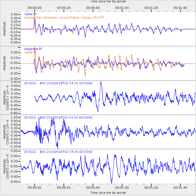
KSU1 Kansas State University--Konza Prairie, Kansas, USA - Earthquake Result Viewer
*The percent match for this event was below the threshold and hence no stack was calculated.
| Earthquake location: |
Kuril Islands |
| Earthquake latitude/longitude: |
44.4/148.7 |
| Earthquake time(UTC): |
2010/06/18 (169) 02:23:05 GMT |
| Earthquake Depth: |
28 km |
| Earthquake Magnitude: |
6.2 MW, 5.9 MB, 6.0 MS, 6.1 MW |
| Earthquake Catalog/Contributor: |
NEIC PDE/NEIC PDE-M |
|
| Network: |
US United States National Seismic Network |
| Station: |
KSU1 Kansas State University--Konza Prairie, Kansas, USA |
| Lat/Lon: |
39.10 N/96.61 W |
| Elevation: |
347 m |
|
| Distance: |
78.1 deg |
| Az: |
46.246 deg |
| Baz: |
318.327 deg |
| Ray Param: |
$rayparam |
*The percent match for this event was below the threshold and hence was not used in the summary stack. |
|
| Radial Match: |
51.920197 % |
| Radial Bump: |
400 |
| Transverse Match: |
58.112183 % |
| Transverse Bump: |
400 |
| SOD ConfigId: |
617450 |
| Insert Time: |
2013-10-01 06:34:37.260 +0000 |
| GWidth: |
2.5 |
| Max Bumps: |
400 |
| Tol: |
0.001 |
|
Signal To Noise
| Channel | StoN | STA | LTA |
| US:KSU1: :BHZ:20100618T02:34:30.923994Z | 1.7689997 | 4.1433037E-7 | 2.3421734E-7 |
| US:KSU1: :BH1:20100618T02:34:30.923994Z | 1.142565 | 1.5280472E-7 | 1.3373831E-7 |
| US:KSU1: :BH2:20100618T02:34:30.923994Z | 2.180215 | 2.2532605E-7 | 1.0335039E-7 |
| Arrivals |
| Ps | |
| PpPs | |
| PsPs/PpSs | |


