You are here: Home > Network List > IU - Global Seismograph Network (GSN - IRIS/USGS) Stations List
> Station RSSD Black Hills, South Dakota, USA > Earthquake Result Viewer
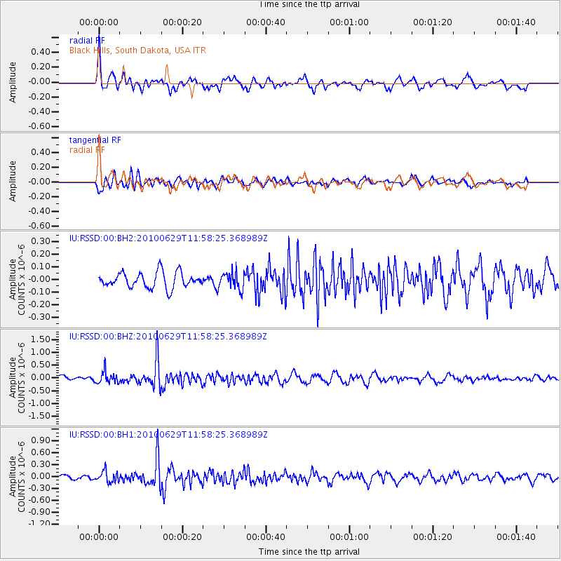
RSSD Black Hills, South Dakota, USA - Earthquake Result Viewer
*The percent match for this event was below the threshold and hence no stack was calculated.
| Earthquake location: |
Kuril Islands |
| Earthquake latitude/longitude: |
48.3/154.3 |
| Earthquake time(UTC): |
2010/06/29 (180) 11:48:19 GMT |
| Earthquake Depth: |
43 km |
| Earthquake Magnitude: |
5.5 MB, 4.9 MS, 5.5 MW, 5.3 MW |
| Earthquake Catalog/Contributor: |
WHDF/NEIC |
|
| Network: |
IU Global Seismograph Network (GSN - IRIS/USGS) |
| Station: |
RSSD Black Hills, South Dakota, USA |
| Lat/Lon: |
44.12 N/104.04 W |
| Elevation: |
2090 m |
|
| Distance: |
65.2 deg |
| Az: |
50.954 deg |
| Baz: |
313.91 deg |
| Ray Param: |
$rayparam |
*The percent match for this event was below the threshold and hence was not used in the summary stack. |
|
| Radial Match: |
78.11155 % |
| Radial Bump: |
400 |
| Transverse Match: |
78.48583 % |
| Transverse Bump: |
400 |
| SOD ConfigId: |
617450 |
| Insert Time: |
2013-10-01 06:59:08.289 +0000 |
| GWidth: |
2.5 |
| Max Bumps: |
400 |
| Tol: |
0.001 |
|
Signal To Noise
| Channel | StoN | STA | LTA |
| IU:RSSD:00:BHZ:20100629T11:58:25.368989Z | 1.6037786 | 2.270626E-7 | 1.4157976E-7 |
| IU:RSSD:00:BH1:20100629T11:58:25.368989Z | 3.0249493 | 1.4260887E-7 | 4.7144216E-8 |
| IU:RSSD:00:BH2:20100629T11:58:25.368989Z | 1.0915536 | 6.6130816E-8 | 6.058413E-8 |
| Arrivals |
| Ps | |
| PpPs | |
| PsPs/PpSs | |


