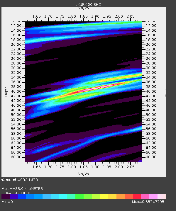
KURK Kurchatov, Kazakhstan - Earthquake Result Viewer
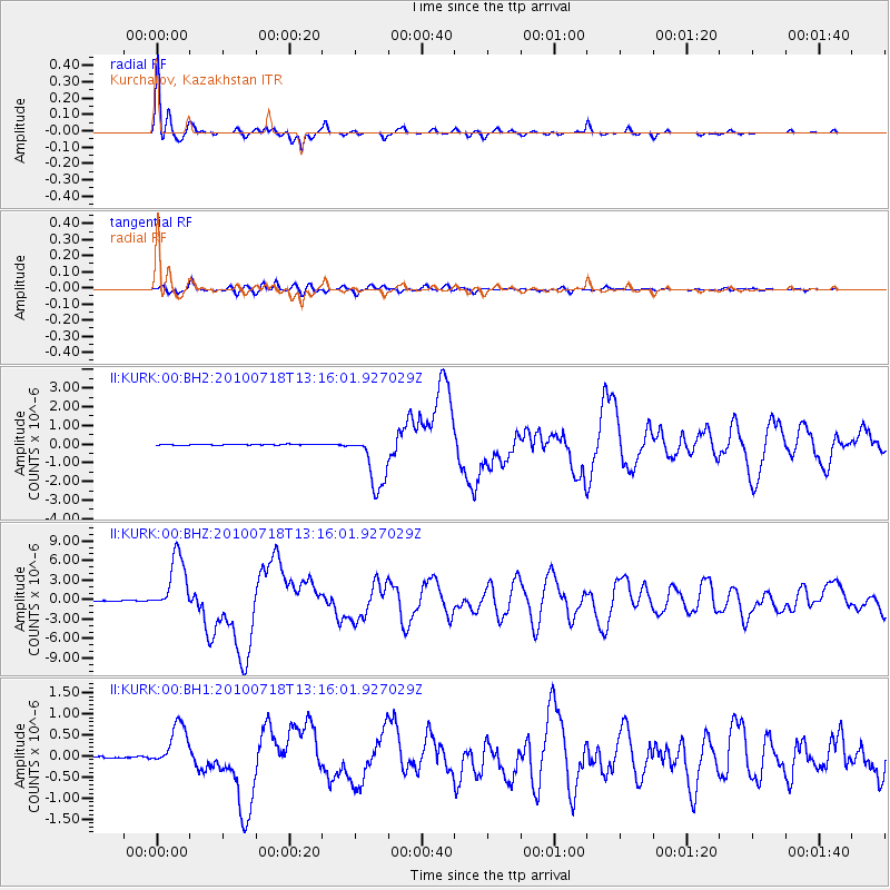
Earthquake location: New Britain Region, P.N.G.
Earthquake latitude/longitude: -6.0/150.4
Earthquake time(UTC): 2010/07/18 (199) 13:04:09 GMT
Earthquake Depth: 28 km
Earthquake Magnitude: 6.3 MB, 7.1 MS, 6.9 MW, 6.8 MW
Earthquake Catalog/Contributor: WHDF/NEIC
Network: II Global Seismograph Network (GSN - IRIS/IDA)
Station: KURK Kurchatov, Kazakhstan
Lat/Lon: 50.72 N/78.62 E
Elevation: 184 m
Distance: 83.2 deg
Az: 322.543 deg
Baz: 107.908 deg
Ray Param: 0.046295393
Estimated Moho Depth: 38.0 km
Estimated Crust Vp/Vs: 1.92
Assumed Crust Vp: 6.552 km/s
Estimated Crust Vs: 3.413 km/s
Estimated Crust Poisson's Ratio: 0.31
Radial Match: 98.11678 %
Radial Bump: 305
Transverse Match: 92.37185 %
Transverse Bump: 400
SOD ConfigId: 617450
Insert Time: 2013-10-01 07:52:20.030 +0000
GWidth: 2.5
Max Bumps: 400
Tol: 0.001

Signal To Noise

ChannelStoNSTALTA
II:KURK:00:BHZ:20100718T13:16:01.927029Z87.199964.434157E-65.0850446E-8
II:KURK:00:BH1:20100718T13:16:01.927029Z16.776875.1812674E-73.0883395E-8
II:KURK:00:BH2:20100718T13:16:01.927029Z70.169031.529744E-62.1800844E-8
Arrivals
Ps5.5 SECOND
PpPs17 SECOND
PsPs/PpSs22 SECOND