You are here: Home > Network List > IU - Global Seismograph Network (GSN - IRIS/USGS) Stations List
> Station HNR Honiara, Solomon Islands > Earthquake Result Viewer
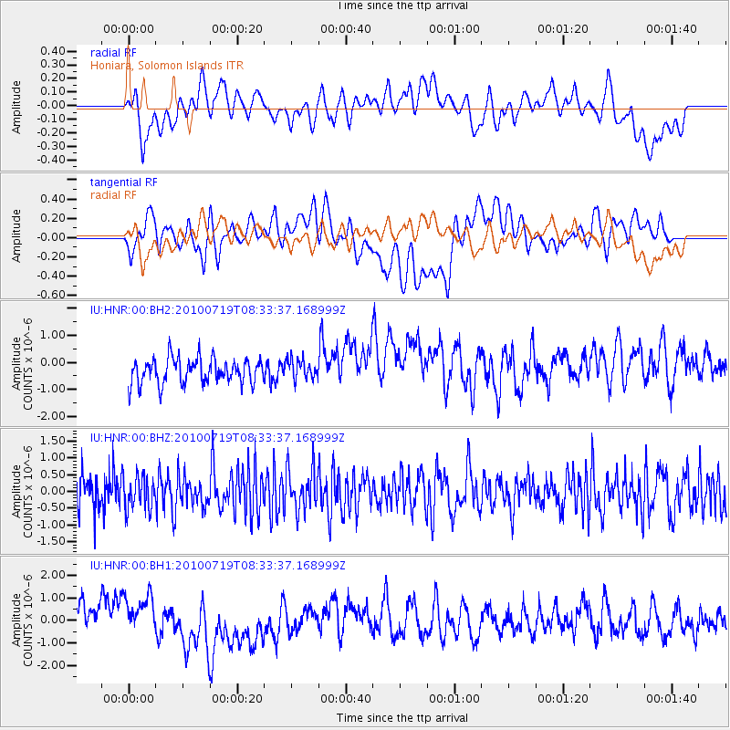
HNR Honiara, Solomon Islands - Earthquake Result Viewer
*The percent match for this event was below the threshold and hence no stack was calculated.
| Earthquake location: |
Fox Islands, Aleutian Islands |
| Earthquake latitude/longitude: |
52.7/-169.6 |
| Earthquake time(UTC): |
2010/07/19 (200) 08:23:14 GMT |
| Earthquake Depth: |
10 km |
| Earthquake Magnitude: |
5.5 MW |
| Earthquake Catalog/Contributor: |
NEIC PDE/NEIC PDE-M |
|
| Network: |
IU Global Seismograph Network (GSN - IRIS/USGS) |
| Station: |
HNR Honiara, Solomon Islands |
| Lat/Lon: |
9.44 S/159.95 E |
| Elevation: |
100 m |
|
| Distance: |
67.2 deg |
| Az: |
212.899 deg |
| Baz: |
19.566 deg |
| Ray Param: |
$rayparam |
*The percent match for this event was below the threshold and hence was not used in the summary stack. |
|
| Radial Match: |
46.899227 % |
| Radial Bump: |
400 |
| Transverse Match: |
34.43997 % |
| Transverse Bump: |
400 |
| SOD ConfigId: |
617450 |
| Insert Time: |
2013-10-01 08:05:17.159 +0000 |
| GWidth: |
2.5 |
| Max Bumps: |
400 |
| Tol: |
0.001 |
|
Signal To Noise
| Channel | StoN | STA | LTA |
| IU:HNR:00:BHZ:20100719T08:33:37.168999Z | 1.0159197 | 4.861859E-7 | 4.785673E-7 |
| IU:HNR:00:BH1:20100719T08:33:37.168999Z | 1.0383373 | 6.1493574E-7 | 5.922312E-7 |
| IU:HNR:00:BH2:20100719T08:33:37.168999Z | 0.76563007 | 3.5936245E-7 | 4.6936825E-7 |
| Arrivals |
| Ps | |
| PpPs | |
| PsPs/PpSs | |


