You are here: Home > Network List > TA - USArray Transportable Network (new EarthScope stations) Stations List
> Station R11A Troy Canyon, Currant, NV, USA > Earthquake Result Viewer
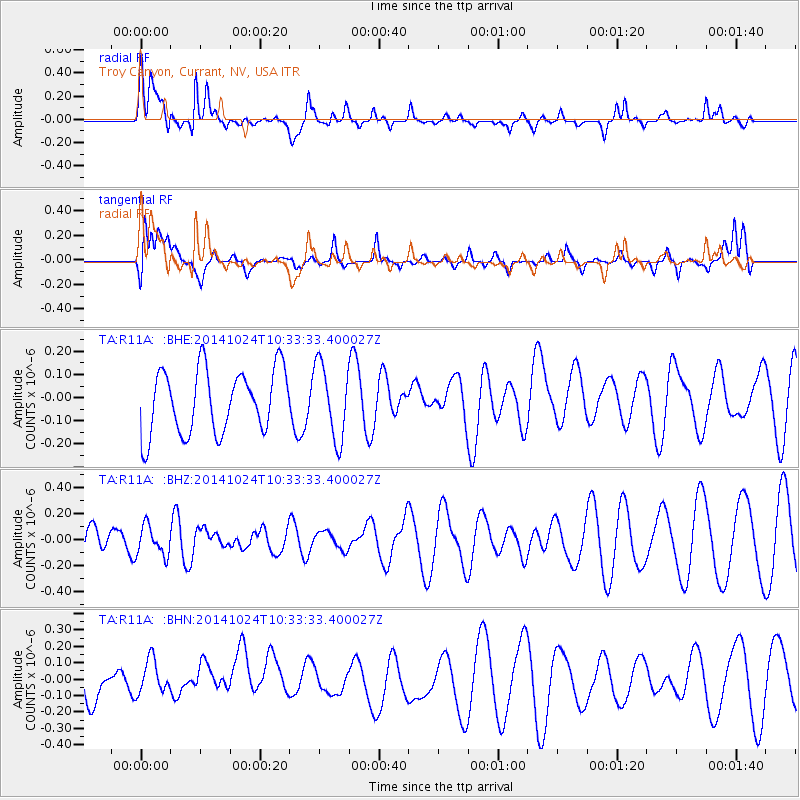
R11A Troy Canyon, Currant, NV, USA - Earthquake Result Viewer
*The percent match for this event was below the threshold and hence no stack was calculated.
| Earthquake location: |
Iceland |
| Earthquake latitude/longitude: |
64.7/-17.4 |
| Earthquake time(UTC): |
2014/10/24 (297) 10:24:02 GMT |
| Earthquake Depth: |
10 km |
| Earthquake Magnitude: |
4.8 MW |
| Earthquake Catalog/Contributor: |
ISC/ISC |
|
| Network: |
TA USArray Transportable Network (new EarthScope stations) |
| Station: |
R11A Troy Canyon, Currant, NV, USA |
| Lat/Lon: |
38.35 N/115.59 W |
| Elevation: |
1756 m |
|
| Distance: |
59.4 deg |
| Az: |
295.234 deg |
| Baz: |
29.618 deg |
| Ray Param: |
$rayparam |
*The percent match for this event was below the threshold and hence was not used in the summary stack. |
|
| Radial Match: |
69.8032 % |
| Radial Bump: |
400 |
| Transverse Match: |
43.37265 % |
| Transverse Bump: |
400 |
| SOD ConfigId: |
3390531 |
| Insert Time: |
2019-04-14 17:20:30.048 +0000 |
| GWidth: |
2.5 |
| Max Bumps: |
400 |
| Tol: |
0.001 |
|
Signal To Noise
| Channel | StoN | STA | LTA |
| TA:R11A: :BHZ:20141024T10:33:33.400027Z | 0.83853287 | 1.14843125E-7 | 1.3695721E-7 |
| TA:R11A: :BHN:20141024T10:33:33.400027Z | 0.9922292 | 1.1630042E-7 | 1.1721124E-7 |
| TA:R11A: :BHE:20141024T10:33:33.400027Z | 1.1712123 | 1.6115766E-7 | 1.3759902E-7 |
| Arrivals |
| Ps | |
| PpPs | |
| PsPs/PpSs | |


