You are here: Home > Network List > II - Global Seismograph Network (GSN - IRIS/IDA) Stations List
> Station MSEY Mahe, Seychelles > Earthquake Result Viewer
MSEY Mahe, Seychelles - Earthquake Result Viewer
| Earthquake location: |
Mindanao, Philippines |
| Earthquake latitude/longitude: |
6.5/123.5 |
| Earthquake time(UTC): |
2010/07/23 (204) 22:51:12 GMT |
| Earthquake Depth: |
586 km |
| Earthquake Magnitude: |
6.9 MB, 7.6 MW, 7.6 MW |
| Earthquake Catalog/Contributor: |
WHDF/NEIC |
|
| Network: |
II Global Seismograph Network (GSN - IRIS/IDA) |
| Station: |
MSEY Mahe, Seychelles |
| Lat/Lon: |
4.67 S/55.48 E |
| Elevation: |
475 m |
|
| Distance: |
68.8 deg |
| Az: |
262.458 deg |
| Baz: |
81.238 deg |
| Ray Param: |
0.054019187 |
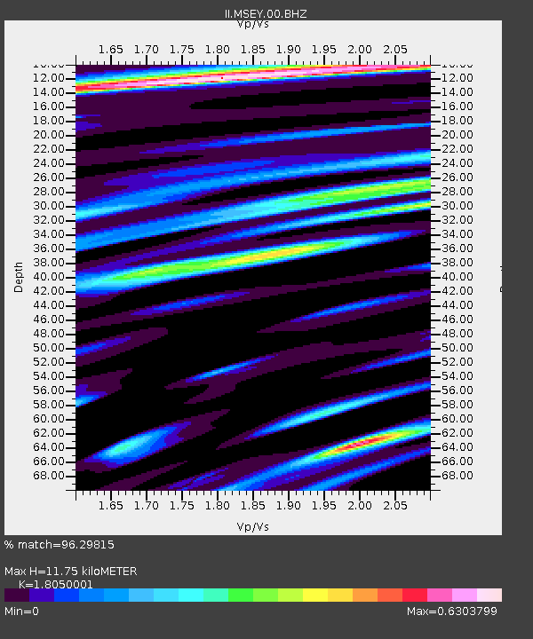
| Estimated Moho Depth: |
11.75 km |
| Estimated Crust Vp/Vs: |
1.81 |
| Assumed Crust Vp: |
6.303 km/s |
| Estimated Crust Vs: |
3.492 km/s |
| Estimated Crust Poisson's Ratio: |
0.28 |
|
| Radial Match: |
96.29815 % |
| Radial Bump: |
400 |
| Transverse Match: |
91.07194 % |
| Transverse Bump: |
400 |
| SOD ConfigId: |
617450 |
| Insert Time: |
2013-10-01 08:31:57.903 +0000 |
| GWidth: |
2.5 |
| Max Bumps: |
400 |
| Tol: |
0.001 |
|

Signal To Noise
| Channel | StoN | STA | LTA |
| II:MSEY:00:BHZ:20100723T23:00:47.926013Z | 3.6775231 | 3.3045924E-6 | 8.9859185E-7 |
| II:MSEY:00:BH1:20100723T23:00:47.926013Z | 1.4900572 | 1.1916887E-6 | 7.9976036E-7 |
| II:MSEY:00:BH2:20100723T23:00:47.926013Z | 0.6692755 | 3.4502142E-7 | 5.155148E-7 |
| Arrivals |
| Ps | 1.6 SECOND |
| PpPs | 5.1 SECOND |
| PsPs/PpSs | 6.6 SECOND |


