You are here: Home > Network List > IU - Global Seismograph Network (GSN - IRIS/USGS) Stations List
> Station HNR Honiara, Solomon Islands > Earthquake Result Viewer
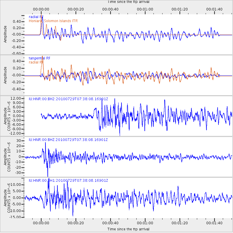
HNR Honiara, Solomon Islands - Earthquake Result Viewer
*The percent match for this event was below the threshold and hence no stack was calculated.
| Earthquake location: |
Mindanao, Philippines |
| Earthquake latitude/longitude: |
6.5/123.2 |
| Earthquake time(UTC): |
2010/07/29 (210) 07:31:56 GMT |
| Earthquake Depth: |
627 km |
| Earthquake Magnitude: |
6.1 MB, 6.6 MW, 6.6 MW |
| Earthquake Catalog/Contributor: |
WHDF/NEIC |
|
| Network: |
IU Global Seismograph Network (GSN - IRIS/USGS) |
| Station: |
HNR Honiara, Solomon Islands |
| Lat/Lon: |
9.44 S/159.95 E |
| Elevation: |
100 m |
|
| Distance: |
39.9 deg |
| Az: |
113.077 deg |
| Baz: |
292.108 deg |
| Ray Param: |
$rayparam |
*The percent match for this event was below the threshold and hence was not used in the summary stack. |
|
| Radial Match: |
63.62352 % |
| Radial Bump: |
400 |
| Transverse Match: |
63.724815 % |
| Transverse Bump: |
400 |
| SOD ConfigId: |
617450 |
| Insert Time: |
2013-10-01 09:00:57.288 +0000 |
| GWidth: |
2.5 |
| Max Bumps: |
400 |
| Tol: |
0.001 |
|
Signal To Noise
| Channel | StoN | STA | LTA |
| IU:HNR:00:BHZ:20100729T07:38:08.16901Z | 12.051302 | 1.2202033E-5 | 1.0125074E-6 |
| IU:HNR:00:BH1:20100729T07:38:08.16901Z | 5.990079 | 5.1817283E-6 | 8.650518E-7 |
| IU:HNR:00:BH2:20100729T07:38:08.16901Z | 4.8168287 | 4.4932694E-6 | 9.3282733E-7 |
| Arrivals |
| Ps | |
| PpPs | |
| PsPs/PpSs | |


