KEV Kevo, Finland - Earthquake Result Viewer
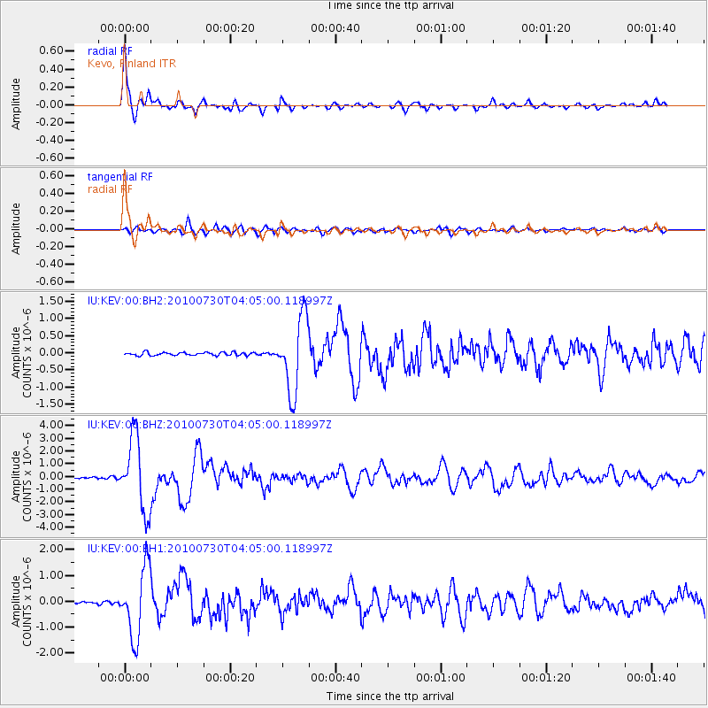
Earthquake location: Off East Coast Of Kamchatka
Earthquake latitude/longitude: 52.5/159.8
Earthquake time(UTC): 2010/07/30 (211) 03:56:13 GMT
Earthquake Depth: 23 km
Earthquake Magnitude: 6.1 MB, 6.3 MS, 6.3 MW, 6.3 MW
Earthquake Catalog/Contributor: WHDF/NEIC
Network: IU Global Seismograph Network (GSN - IRIS/USGS)
Station: KEV Kevo, Finland
Lat/Lon: 69.76 N/27.00 E
Elevation: 100 m
Distance: 53.3 deg
Az: 341.447 deg
Baz: 33.979 deg
Ray Param: 0.06613751
Estimated Moho Depth: 38.25 km
Estimated Crust Vp/Vs: 1.74
Assumed Crust Vp: 6.622 km/s
Estimated Crust Vs: 3.817 km/s
Estimated Crust Poisson's Ratio: 0.25
Radial Match: 96.26871 %
Radial Bump: 316
Transverse Match: 82.65223 %
Transverse Bump: 400
SOD ConfigId: 617450
Insert Time: 2013-10-01 09:03:37.752 +0000
GWidth: 2.5
Max Bumps: 400
Tol: 0.001

Signal To Noise

ChannelStoNSTALTA
IU:KEV:00:BHZ:20100730T04:05:00.118997Z49.989392.9103926E-65.8220206E-8
IU:KEV:00:BH1:20100730T04:05:00.118997Z23.220071.3560439E-65.8399642E-8
IU:KEV:00:BH2:20100730T04:05:00.118997Z24.6920051.1018204E-64.462256E-8
Arrivals
Ps4.5 SECOND
PpPs15 SECOND
PsPs/PpSs19 SECOND