You are here: Home > Network List > IU - Global Seismograph Network (GSN - IRIS/USGS) Stations List
> Station HNR Honiara, Solomon Islands > Earthquake Result Viewer
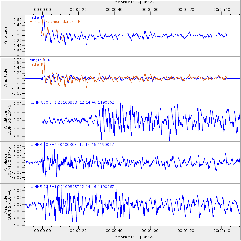
HNR Honiara, Solomon Islands - Earthquake Result Viewer
*The percent match for this event was below the threshold and hence no stack was calculated.
| Earthquake location: |
Northern Molucca Sea |
| Earthquake latitude/longitude: |
1.2/126.2 |
| Earthquake time(UTC): |
2010/08/03 (215) 12:08:25 GMT |
| Earthquake Depth: |
41 km |
| Earthquake Magnitude: |
6.1 MB, 5.9 MS, 6.3 MW, 6.3 MW |
| Earthquake Catalog/Contributor: |
WHDF/NEIC |
|
| Network: |
IU Global Seismograph Network (GSN - IRIS/USGS) |
| Station: |
HNR Honiara, Solomon Islands |
| Lat/Lon: |
9.44 S/159.95 E |
| Elevation: |
100 m |
|
| Distance: |
35.2 deg |
| Az: |
108.234 deg |
| Baz: |
285.756 deg |
| Ray Param: |
$rayparam |
*The percent match for this event was below the threshold and hence was not used in the summary stack. |
|
| Radial Match: |
77.028114 % |
| Radial Bump: |
400 |
| Transverse Match: |
70.25994 % |
| Transverse Bump: |
400 |
| SOD ConfigId: |
617450 |
| Insert Time: |
2013-10-01 09:15:43.666 +0000 |
| GWidth: |
2.5 |
| Max Bumps: |
400 |
| Tol: |
0.001 |
|
Signal To Noise
| Channel | StoN | STA | LTA |
| IU:HNR:00:BHZ:20100803T12:14:46.119006Z | 9.420022 | 4.0405716E-6 | 4.289344E-7 |
| IU:HNR:00:BH1:20100803T12:14:46.119006Z | 5.440609 | 2.0551745E-6 | 3.7774714E-7 |
| IU:HNR:00:BH2:20100803T12:14:46.119006Z | 5.234839 | 1.9516035E-6 | 3.728106E-7 |
| Arrivals |
| Ps | |
| PpPs | |
| PsPs/PpSs | |


