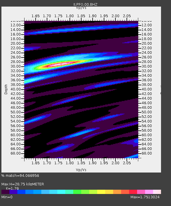
PFO Pinon Flat, California, USA - Earthquake Result Viewer
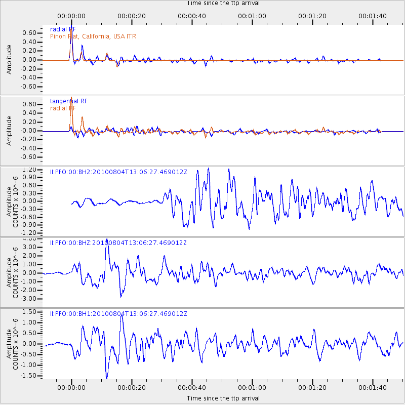
Earthquake location: Andreanof Islands, Aleutian Is.
Earthquake latitude/longitude: 51.4/-178.6
Earthquake time(UTC): 2010/08/04 (216) 12:58:24 GMT
Earthquake Depth: 27 km
Earthquake Magnitude: 6.4 MW, 6.2 MB, 6.2 MS, 6.4 MW
Earthquake Catalog/Contributor: NEIC PDE/NEIC PDE-M
Network: II Global Seismograph Network (GSN - IRIS/IDA)
Station: PFO Pinon Flat, California, USA
Lat/Lon: 33.61 N/116.46 W
Elevation: 1280 m
Distance: 47.7 deg
Az: 86.787 deg
Baz: 311.488 deg
Ray Param: 0.06979404
Estimated Moho Depth: 28.75 km
Estimated Crust Vp/Vs: 1.76
Assumed Crust Vp: 6.264 km/s
Estimated Crust Vs: 3.559 km/s
Estimated Crust Poisson's Ratio: 0.26
Radial Match: 94.066956 %
Radial Bump: 244
Transverse Match: 81.38507 %
Transverse Bump: 400
SOD ConfigId: 617450
Insert Time: 2013-10-01 09:26:01.026 +0000
GWidth: 2.5
Max Bumps: 400
Tol: 0.001

Signal To Noise

ChannelStoNSTALTA
II:PFO:00:BHZ:20100804T13:06:27.469012Z10.9057627.901762E-77.245493E-8
II:PFO:00:BH1:20100804T13:06:27.469012Z5.2218664.5361423E-78.686822E-8
II:PFO:00:BH2:20100804T13:06:27.469012Z3.8581712.8664795E-77.429633E-8
Arrivals
Ps3.7 SECOND
PpPs12 SECOND
PsPs/PpSs16 SECOND