You are here: Home > Network List > IU - Global Seismograph Network (GSN - IRIS/USGS) Stations List
> Station HNR Honiara, Solomon Islands > Earthquake Result Viewer
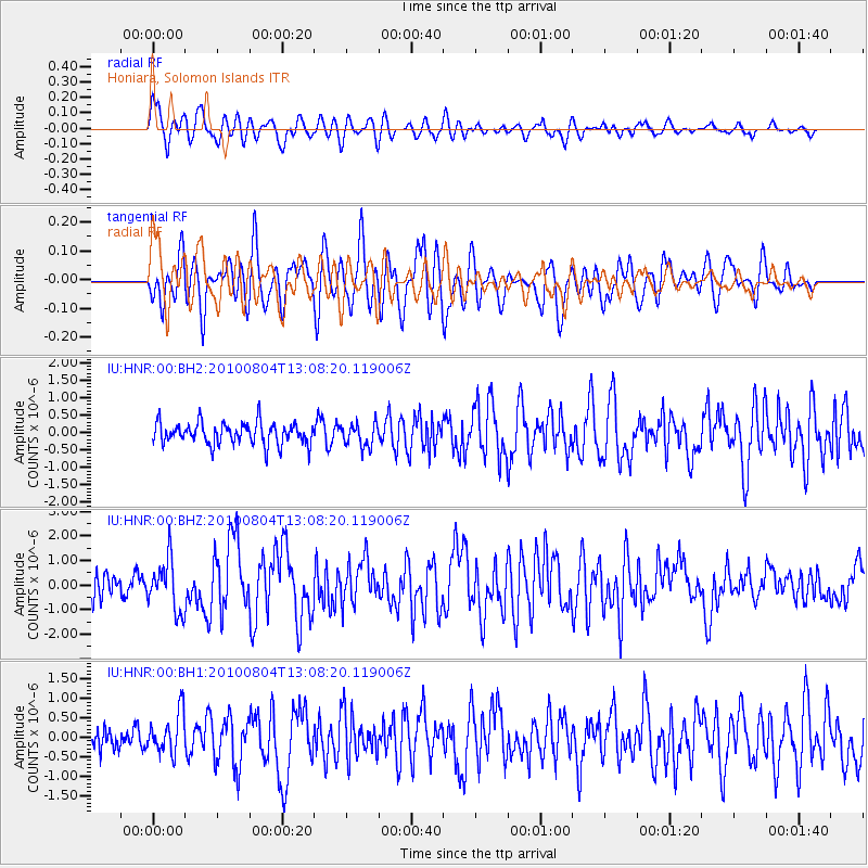
HNR Honiara, Solomon Islands - Earthquake Result Viewer
*The percent match for this event was below the threshold and hence no stack was calculated.
| Earthquake location: |
Andreanof Islands, Aleutian Is. |
| Earthquake latitude/longitude: |
51.4/-178.6 |
| Earthquake time(UTC): |
2010/08/04 (216) 12:58:24 GMT |
| Earthquake Depth: |
27 km |
| Earthquake Magnitude: |
6.4 MW, 6.2 MB, 6.2 MS, 6.4 MW |
| Earthquake Catalog/Contributor: |
NEIC PDE/NEIC PDE-M |
|
| Network: |
IU Global Seismograph Network (GSN - IRIS/USGS) |
| Station: |
HNR Honiara, Solomon Islands |
| Lat/Lon: |
9.44 S/159.95 E |
| Elevation: |
100 m |
|
| Distance: |
63.4 deg |
| Az: |
203.751 deg |
| Baz: |
14.809 deg |
| Ray Param: |
$rayparam |
*The percent match for this event was below the threshold and hence was not used in the summary stack. |
|
| Radial Match: |
74.98136 % |
| Radial Bump: |
400 |
| Transverse Match: |
71.11271 % |
| Transverse Bump: |
400 |
| SOD ConfigId: |
617450 |
| Insert Time: |
2013-10-01 09:26:16.344 +0000 |
| GWidth: |
2.5 |
| Max Bumps: |
400 |
| Tol: |
0.001 |
|
Signal To Noise
| Channel | StoN | STA | LTA |
| IU:HNR:00:BHZ:20100804T13:08:20.119006Z | 2.4159236 | 1.0390186E-6 | 4.3007094E-7 |
| IU:HNR:00:BH1:20100804T13:08:20.119006Z | 1.9592104 | 5.2493056E-7 | 2.6792966E-7 |
| IU:HNR:00:BH2:20100804T13:08:20.119006Z | 1.0393268 | 3.2733263E-7 | 3.149468E-7 |
| Arrivals |
| Ps | |
| PpPs | |
| PsPs/PpSs | |


