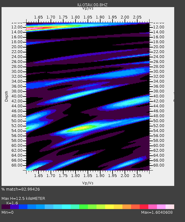
OTAV Otavalo, Ecuador - Earthquake Result Viewer
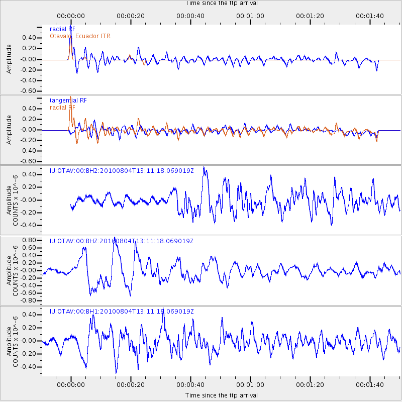
Earthquake location: Andreanof Islands, Aleutian Is.
Earthquake latitude/longitude: 51.4/-178.6
Earthquake time(UTC): 2010/08/04 (216) 12:58:24 GMT
Earthquake Depth: 27 km
Earthquake Magnitude: 6.4 MW, 6.2 MB, 6.2 MS, 6.4 MW
Earthquake Catalog/Contributor: NEIC PDE/NEIC PDE-M
Network: IU Global Seismograph Network (GSN - IRIS/USGS)
Station: OTAV Otavalo, Ecuador
Lat/Lon: 0.24 N/78.45 W
Elevation: 3510 m
Distance: 96.2 deg
Az: 81.868 deg
Baz: 321.696 deg
Ray Param: 0.040574983
Estimated Moho Depth: 12.5 km
Estimated Crust Vp/Vs: 1.60
Assumed Crust Vp: 6.472 km/s
Estimated Crust Vs: 4.045 km/s
Estimated Crust Poisson's Ratio: 0.18
Radial Match: 82.99426 %
Radial Bump: 400
Transverse Match: 62.517735 %
Transverse Bump: 400
SOD ConfigId: 617450
Insert Time: 2013-10-01 09:26:20.614 +0000
GWidth: 2.5
Max Bumps: 400
Tol: 0.001

Signal To Noise

ChannelStoNSTALTA
IU:OTAV:00:BHZ:20100804T13:11:18.069019Z4.75597523.144137E-76.6109195E-8
IU:OTAV:00:BH1:20100804T13:11:18.069019Z2.8166461.692663E-76.009498E-8
IU:OTAV:00:BH2:20100804T13:11:18.069019Z1.56103599.117593E-85.8407327E-8
Arrivals
Ps1.2 SECOND
PpPs4.9 SECOND
PsPs/PpSs6.1 SECOND