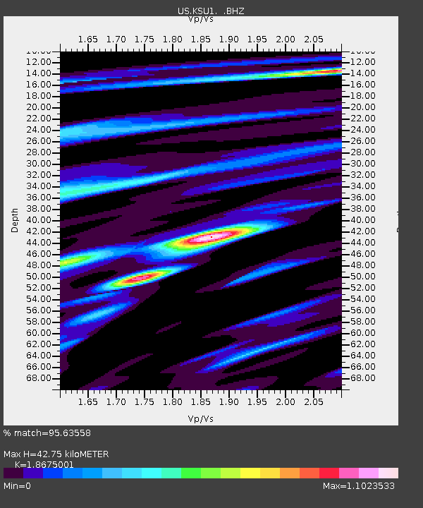
KSU1 Kansas State University--Konza Prairie, Kansas, USA - Earthquake Result Viewer

Earthquake location: Andreanof Islands, Aleutian Is.
Earthquake latitude/longitude: 51.4/-178.6
Earthquake time(UTC): 2010/08/04 (216) 12:58:24 GMT
Earthquake Depth: 27 km
Earthquake Magnitude: 6.4 MW, 6.2 MB, 6.2 MS, 6.4 MW
Earthquake Catalog/Contributor: NEIC PDE/NEIC PDE-M
Network: US United States National Seismic Network
Station: KSU1 Kansas State University--Konza Prairie, Kansas, USA
Lat/Lon: 39.10 N/96.61 W
Elevation: 347 m
Distance: 56.1 deg
Az: 68.133 deg
Baz: 311.688 deg
Ray Param: 0.064296804
Estimated Moho Depth: 42.75 km
Estimated Crust Vp/Vs: 1.87
Assumed Crust Vp: 6.483 km/s
Estimated Crust Vs: 3.471 km/s
Estimated Crust Poisson's Ratio: 0.30
Radial Match: 95.63558 %
Radial Bump: 400
Transverse Match: 92.241455 %
Transverse Bump: 400
SOD ConfigId: 617450
Insert Time: 2013-10-01 09:26:43.665 +0000
GWidth: 2.5
Max Bumps: 400
Tol: 0.001

Signal To Noise

ChannelStoNSTALTA
US:KSU1: :BHZ:20100804T13:07:30.398975Z55.0354773.9874667E-67.2452664E-8
US:KSU1: :BH1:20100804T13:07:30.398975Z9.0753086.131447E-76.7561864E-8
US:KSU1: :BH2:20100804T13:07:30.398975Z20.2042541.3119096E-66.4932344E-8
Arrivals
Ps6.0 SECOND
PpPs18 SECOND
PsPs/PpSs24 SECOND