You are here: Home > Network List > IU - Global Seismograph Network (GSN - IRIS/USGS) Stations List
> Station RSSD Black Hills, South Dakota, USA > Earthquake Result Viewer
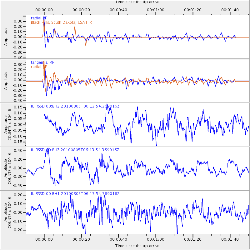
RSSD Black Hills, South Dakota, USA - Earthquake Result Viewer
*The percent match for this event was below the threshold and hence no stack was calculated.
| Earthquake location: |
Near Coast Of Central Chile |
| Earthquake latitude/longitude: |
-37.4/-73.3 |
| Earthquake time(UTC): |
2010/08/05 (217) 06:01:47 GMT |
| Earthquake Depth: |
18 km |
| Earthquake Magnitude: |
5.5 MS, 5.4 MB, 5.9 MW, 5.8 MW |
| Earthquake Catalog/Contributor: |
WHDF/NEIC |
|
| Network: |
IU Global Seismograph Network (GSN - IRIS/USGS) |
| Station: |
RSSD Black Hills, South Dakota, USA |
| Lat/Lon: |
44.12 N/104.04 W |
| Elevation: |
2090 m |
|
| Distance: |
85.8 deg |
| Az: |
338.33 deg |
| Baz: |
155.915 deg |
| Ray Param: |
$rayparam |
*The percent match for this event was below the threshold and hence was not used in the summary stack. |
|
| Radial Match: |
74.49235 % |
| Radial Bump: |
400 |
| Transverse Match: |
86.02604 % |
| Transverse Bump: |
400 |
| SOD ConfigId: |
617450 |
| Insert Time: |
2013-10-01 09:33:03.274 +0000 |
| GWidth: |
2.5 |
| Max Bumps: |
400 |
| Tol: |
0.001 |
|
Signal To Noise
| Channel | StoN | STA | LTA |
| IU:RSSD:00:BHZ:20100805T06:13:54.369016Z | 2.6506987 | 2.7920038E-7 | 1.0533086E-7 |
| IU:RSSD:00:BH1:20100805T06:13:54.369016Z | 0.86155826 | 5.6937516E-8 | 6.608667E-8 |
| IU:RSSD:00:BH2:20100805T06:13:54.369016Z | 1.5232552 | 7.753862E-8 | 5.0903232E-8 |
| Arrivals |
| Ps | |
| PpPs | |
| PsPs/PpSs | |


