You are here: Home > Network List > IU - Global Seismograph Network (GSN - IRIS/USGS) Stations List
> Station JOHN Johnston Island, USA > Earthquake Result Viewer
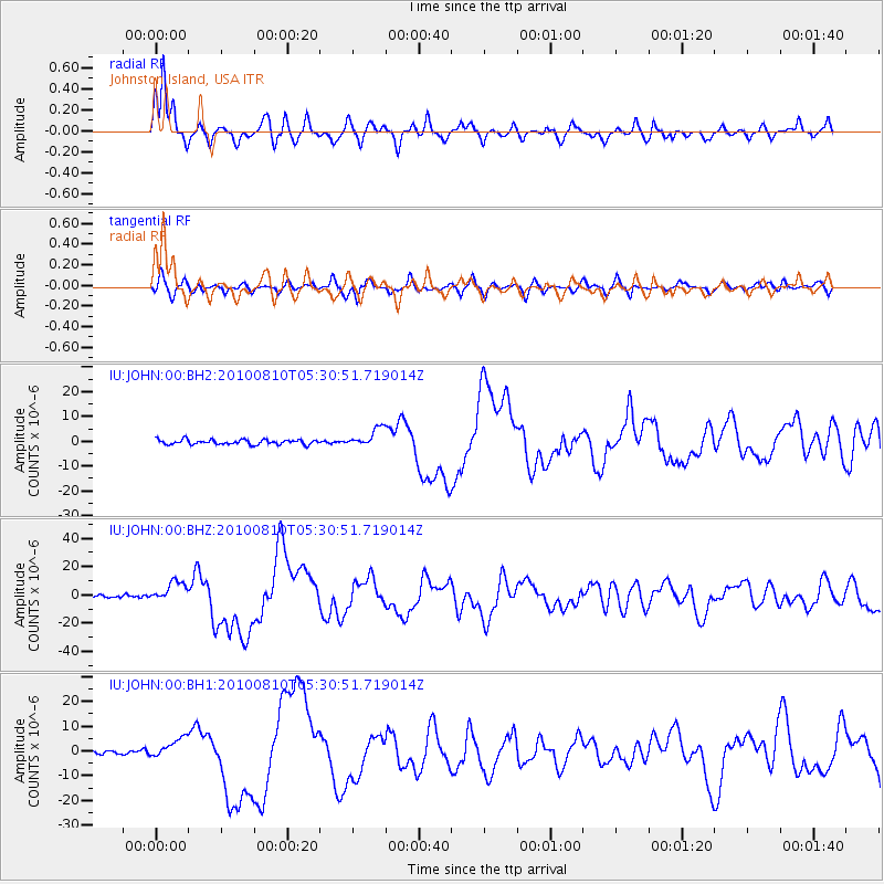
JOHN Johnston Island, USA - Earthquake Result Viewer
*The percent match for this event was below the threshold and hence no stack was calculated.
| Earthquake location: |
Vanuatu Islands |
| Earthquake latitude/longitude: |
-17.5/168.1 |
| Earthquake time(UTC): |
2010/08/10 (222) 05:23:44 GMT |
| Earthquake Depth: |
25 km |
| Earthquake Magnitude: |
6.4 MB, 7.3 MS, 7.3 MW, 7.2 MW |
| Earthquake Catalog/Contributor: |
WHDF/NEIC |
|
| Network: |
IU Global Seismograph Network (GSN - IRIS/USGS) |
| Station: |
JOHN Johnston Island, USA |
| Lat/Lon: |
16.73 N/169.53 W |
| Elevation: |
2.0 m |
|
| Distance: |
40.6 deg |
| Az: |
34.148 deg |
| Baz: |
213.982 deg |
| Ray Param: |
$rayparam |
*The percent match for this event was below the threshold and hence was not used in the summary stack. |
|
| Radial Match: |
94.26845 % |
| Radial Bump: |
400 |
| Transverse Match: |
71.245895 % |
| Transverse Bump: |
400 |
| SOD ConfigId: |
617450 |
| Insert Time: |
2013-10-01 09:42:43.967 +0000 |
| GWidth: |
2.5 |
| Max Bumps: |
400 |
| Tol: |
0.001 |
|
Signal To Noise
| Channel | StoN | STA | LTA |
| IU:JOHN:00:BHZ:20100810T05:30:51.719014Z | 6.6087008 | 7.414934E-6 | 1.1219958E-6 |
| IU:JOHN:00:BH1:20100810T05:30:51.719014Z | 4.1571054 | 4.1215553E-6 | 9.914484E-7 |
| IU:JOHN:00:BH2:20100810T05:30:51.719014Z | 3.9257927 | 3.7524896E-6 | 9.558553E-7 |
| Arrivals |
| Ps | |
| PpPs | |
| PsPs/PpSs | |


