You are here: Home > Network List > II - Global Seismograph Network (GSN - IRIS/IDA) Stations List
> Station PFO Pinon Flat, California, USA > Earthquake Result Viewer
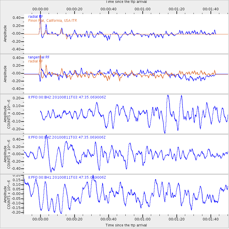
PFO Pinon Flat, California, USA - Earthquake Result Viewer
*The percent match for this event was below the threshold and hence no stack was calculated.
| Earthquake location: |
Vanuatu Islands |
| Earthquake latitude/longitude: |
-17.4/167.8 |
| Earthquake time(UTC): |
2010/08/11 (223) 03:35:19 GMT |
| Earthquake Depth: |
35 km |
| Earthquake Magnitude: |
5.6 MB, 5.7 MS, 5.8 MW |
| Earthquake Catalog/Contributor: |
WHDF/NEIC |
|
| Network: |
II Global Seismograph Network (GSN - IRIS/IDA) |
| Station: |
PFO Pinon Flat, California, USA |
| Lat/Lon: |
33.61 N/116.46 W |
| Elevation: |
1280 m |
|
| Distance: |
88.1 deg |
| Az: |
54.019 deg |
| Baz: |
247.794 deg |
| Ray Param: |
$rayparam |
*The percent match for this event was below the threshold and hence was not used in the summary stack. |
|
| Radial Match: |
76.10697 % |
| Radial Bump: |
400 |
| Transverse Match: |
39.24937 % |
| Transverse Bump: |
400 |
| SOD ConfigId: |
617450 |
| Insert Time: |
2013-10-01 09:48:40.224 +0000 |
| GWidth: |
2.5 |
| Max Bumps: |
400 |
| Tol: |
0.001 |
|
Signal To Noise
| Channel | StoN | STA | LTA |
| II:PFO:00:BHZ:20100811T03:47:35.069006Z | 2.9911668 | 2.6159208E-7 | 8.745486E-8 |
| II:PFO:00:BH1:20100811T03:47:35.069006Z | 1.6336755 | 1.5878705E-7 | 9.71962E-8 |
| II:PFO:00:BH2:20100811T03:47:35.069006Z | 2.14402 | 7.6568426E-8 | 3.571255E-8 |
| Arrivals |
| Ps | |
| PpPs | |
| PsPs/PpSs | |


