You are here: Home > Network List > II - Global Seismograph Network (GSN - IRIS/IDA) Stations List
> Station AAK Ala Archa, Kyrgyzstan > Earthquake Result Viewer
AAK Ala Archa, Kyrgyzstan - Earthquake Result Viewer
| Earthquake location: |
South Of Mariana Islands |
| Earthquake latitude/longitude: |
12.5/141.5 |
| Earthquake time(UTC): |
2010/08/13 (225) 21:19:33 GMT |
| Earthquake Depth: |
10 km |
| Earthquake Magnitude: |
6.5 MB, 6.9 MS, 6.9 MW, 6.9 MW |
| Earthquake Catalog/Contributor: |
WHDF/NEIC |
|
| Network: |
II Global Seismograph Network (GSN - IRIS/IDA) |
| Station: |
AAK Ala Archa, Kyrgyzstan |
| Lat/Lon: |
42.64 N/74.49 E |
| Elevation: |
1645 m |
|
| Distance: |
64.7 deg |
| Az: |
311.326 deg |
| Baz: |
96.301 deg |
| Ray Param: |
0.058730043 |
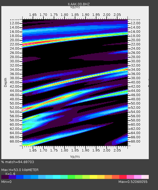
| Estimated Moho Depth: |
53.0 km |
| Estimated Crust Vp/Vs: |
1.60 |
| Assumed Crust Vp: |
6.306 km/s |
| Estimated Crust Vs: |
3.941 km/s |
| Estimated Crust Poisson's Ratio: |
0.18 |
|
| Radial Match: |
94.69703 % |
| Radial Bump: |
400 |
| Transverse Match: |
96.02742 % |
| Transverse Bump: |
378 |
| SOD ConfigId: |
617450 |
| Insert Time: |
2013-10-01 09:59:34.968 +0000 |
| GWidth: |
2.5 |
| Max Bumps: |
400 |
| Tol: |
0.001 |
|

Signal To Noise
| Channel | StoN | STA | LTA |
| II:AAK:00:BHZ:20100813T21:29:40.319004Z | 11.627037 | 6.600601E-7 | 5.6769412E-8 |
| II:AAK:00:BH1:20100813T21:29:40.319004Z | 2.6791685 | 9.069879E-8 | 3.3853336E-8 |
| II:AAK:00:BH2:20100813T21:29:40.319004Z | 12.554971 | 2.579452E-7 | 2.0545265E-8 |
| Arrivals |
| Ps | 5.3 SECOND |
| PpPs | 21 SECOND |
| PsPs/PpSs | 26 SECOND |


