You are here: Home > Network List > IU - Global Seismograph Network (GSN - IRIS/USGS) Stations List
> Station HNR Honiara, Solomon Islands > Earthquake Result Viewer
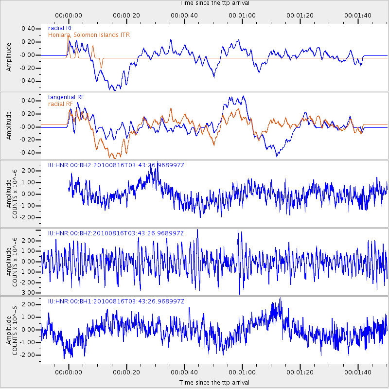
HNR Honiara, Solomon Islands - Earthquake Result Viewer
*The percent match for this event was below the threshold and hence no stack was calculated.
| Earthquake location: |
Mauritius - Reunion Region |
| Earthquake latitude/longitude: |
-17.8/65.6 |
| Earthquake time(UTC): |
2010/08/16 (228) 03:30:53 GMT |
| Earthquake Depth: |
9.8 km |
| Earthquake Magnitude: |
5.7 MB, 6.0 MS, 6.3 MW, 6.3 MW |
| Earthquake Catalog/Contributor: |
WHDF/NEIC |
|
| Network: |
IU Global Seismograph Network (GSN - IRIS/USGS) |
| Station: |
HNR Honiara, Solomon Islands |
| Lat/Lon: |
9.44 S/159.95 E |
| Elevation: |
100 m |
|
| Distance: |
91.2 deg |
| Az: |
100.237 deg |
| Baz: |
251.891 deg |
| Ray Param: |
$rayparam |
*The percent match for this event was below the threshold and hence was not used in the summary stack. |
|
| Radial Match: |
21.108671 % |
| Radial Bump: |
400 |
| Transverse Match: |
26.205156 % |
| Transverse Bump: |
400 |
| SOD ConfigId: |
617450 |
| Insert Time: |
2013-10-01 10:23:57.660 +0000 |
| GWidth: |
2.5 |
| Max Bumps: |
400 |
| Tol: |
0.001 |
|
Signal To Noise
| Channel | StoN | STA | LTA |
| IU:HNR:00:BHZ:20100816T03:43:26.968997Z | 1.385608 | 1.1825126E-6 | 8.5342504E-7 |
| IU:HNR:00:BH1:20100816T03:43:26.968997Z | 2.9266808 | 1.3687571E-6 | 4.676824E-7 |
| IU:HNR:00:BH2:20100816T03:43:26.968997Z | 1.7012542 | 1.0304748E-6 | 6.057147E-7 |
| Arrivals |
| Ps | |
| PpPs | |
| PsPs/PpSs | |


