You are here: Home > Network List > II - Global Seismograph Network (GSN - IRIS/IDA) Stations List
> Station PFO Pinon Flat, California, USA > Earthquake Result Viewer
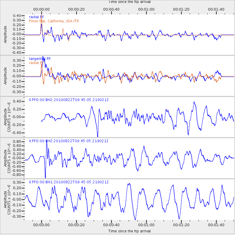
PFO Pinon Flat, California, USA - Earthquake Result Viewer
*The percent match for this event was below the threshold and hence no stack was calculated.
| Earthquake location: |
Mariana Islands Region |
| Earthquake latitude/longitude: |
19.4/147.4 |
| Earthquake time(UTC): |
2010/08/22 (234) 09:33:06 GMT |
| Earthquake Depth: |
23 km |
| Earthquake Magnitude: |
5.9 MB, 5.3 MS, 5.5 MW |
| Earthquake Catalog/Contributor: |
WHDF/NEIC |
|
| Network: |
II Global Seismograph Network (GSN - IRIS/IDA) |
| Station: |
PFO Pinon Flat, California, USA |
| Lat/Lon: |
33.61 N/116.46 W |
| Elevation: |
1280 m |
|
| Distance: |
84.4 deg |
| Az: |
56.479 deg |
| Baz: |
289.484 deg |
| Ray Param: |
$rayparam |
*The percent match for this event was below the threshold and hence was not used in the summary stack. |
|
| Radial Match: |
64.91779 % |
| Radial Bump: |
400 |
| Transverse Match: |
77.903625 % |
| Transverse Bump: |
400 |
| SOD ConfigId: |
617450 |
| Insert Time: |
2013-10-01 10:35:07.524 +0000 |
| GWidth: |
2.5 |
| Max Bumps: |
400 |
| Tol: |
0.001 |
|
Signal To Noise
| Channel | StoN | STA | LTA |
| II:PFO:00:BHZ:20100822T09:45:05.219021Z | 5.271256 | 3.6855016E-7 | 6.991695E-8 |
| II:PFO:00:BH1:20100822T09:45:05.219021Z | 1.6306957 | 9.450149E-8 | 5.7951638E-8 |
| II:PFO:00:BH2:20100822T09:45:05.219021Z | 3.6566167 | 2.0265543E-7 | 5.542157E-8 |
| Arrivals |
| Ps | |
| PpPs | |
| PsPs/PpSs | |


