You are here: Home > Network List > IU - Global Seismograph Network (GSN - IRIS/USGS) Stations List
> Station RSSD Black Hills, South Dakota, USA > Earthquake Result Viewer
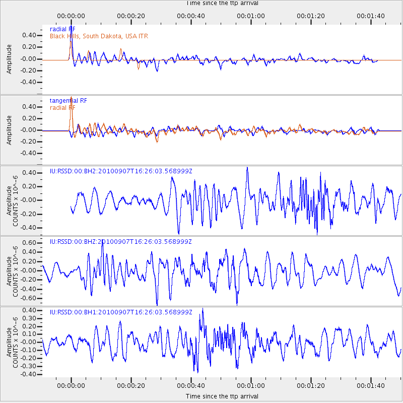
RSSD Black Hills, South Dakota, USA - Earthquake Result Viewer
*The percent match for this event was below the threshold and hence no stack was calculated.
| Earthquake location: |
Fiji Islands Region |
| Earthquake latitude/longitude: |
-15.9/-179.3 |
| Earthquake time(UTC): |
2010/09/07 (250) 16:13:32 GMT |
| Earthquake Depth: |
10 km |
| Earthquake Magnitude: |
5.7 MB, 6.0 MS, 6.3 MW, 6.2 MW |
| Earthquake Catalog/Contributor: |
WHDF/NEIC |
|
| Network: |
IU Global Seismograph Network (GSN - IRIS/USGS) |
| Station: |
RSSD Black Hills, South Dakota, USA |
| Lat/Lon: |
44.12 N/104.04 W |
| Elevation: |
2090 m |
|
| Distance: |
90.7 deg |
| Az: |
44.154 deg |
| Baz: |
248.555 deg |
| Ray Param: |
$rayparam |
*The percent match for this event was below the threshold and hence was not used in the summary stack. |
|
| Radial Match: |
68.53226 % |
| Radial Bump: |
400 |
| Transverse Match: |
47.149494 % |
| Transverse Bump: |
400 |
| SOD ConfigId: |
617450 |
| Insert Time: |
2013-10-01 11:16:17.674 +0000 |
| GWidth: |
2.5 |
| Max Bumps: |
400 |
| Tol: |
0.001 |
|
Signal To Noise
| Channel | StoN | STA | LTA |
| IU:RSSD:00:BHZ:20100907T16:26:03.568999Z | 1.2561246 | 1.3319199E-7 | 1.0603405E-7 |
| IU:RSSD:00:BH1:20100907T16:26:03.568999Z | 0.7555204 | 6.255579E-8 | 8.279829E-8 |
| IU:RSSD:00:BH2:20100907T16:26:03.568999Z | 1.8579153 | 1.765658E-7 | 9.5034366E-8 |
| Arrivals |
| Ps | |
| PpPs | |
| PsPs/PpSs | |


