You are here: Home > Network List > II - Global Seismograph Network (GSN - IRIS/IDA) Stations List
> Station WRAB Tennant Creek, NT, Australia > Earthquake Result Viewer
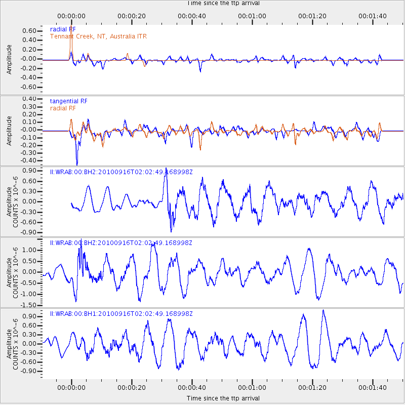
WRAB Tennant Creek, NT, Australia - Earthquake Result Viewer
*The percent match for this event was below the threshold and hence no stack was calculated.
| Earthquake location: |
Tonga Islands |
| Earthquake latitude/longitude: |
-16.0/-174.0 |
| Earthquake time(UTC): |
2010/09/16 (259) 01:54:40 GMT |
| Earthquake Depth: |
84 km |
| Earthquake Magnitude: |
5.5 MB, 5.8 MW, 5.8 MW |
| Earthquake Catalog/Contributor: |
WHDF/NEIC |
|
| Network: |
II Global Seismograph Network (GSN - IRIS/IDA) |
| Station: |
WRAB Tennant Creek, NT, Australia |
| Lat/Lon: |
19.93 S/134.36 E |
| Elevation: |
366 m |
|
| Distance: |
49.2 deg |
| Az: |
257.34 deg |
| Baz: |
94.255 deg |
| Ray Param: |
$rayparam |
*The percent match for this event was below the threshold and hence was not used in the summary stack. |
|
| Radial Match: |
59.316456 % |
| Radial Bump: |
400 |
| Transverse Match: |
85.53532 % |
| Transverse Bump: |
400 |
| SOD ConfigId: |
617450 |
| Insert Time: |
2013-10-01 11:39:52.547 +0000 |
| GWidth: |
2.5 |
| Max Bumps: |
400 |
| Tol: |
0.001 |
|
Signal To Noise
| Channel | StoN | STA | LTA |
| II:WRAB:00:BHZ:20100916T02:02:49.168998Z | 3.0412488 | 7.468603E-7 | 2.4557684E-7 |
| II:WRAB:00:BH1:20100916T02:02:49.168998Z | 1.0959245 | 2.2331052E-7 | 2.037645E-7 |
| II:WRAB:00:BH2:20100916T02:02:49.168998Z | 2.3924148 | 4.9154056E-7 | 2.0545792E-7 |
| Arrivals |
| Ps | |
| PpPs | |
| PsPs/PpSs | |


