You are here: Home > Network List > IU - Global Seismograph Network (GSN - IRIS/USGS) Stations List
> Station RSSD Black Hills, South Dakota, USA > Earthquake Result Viewer
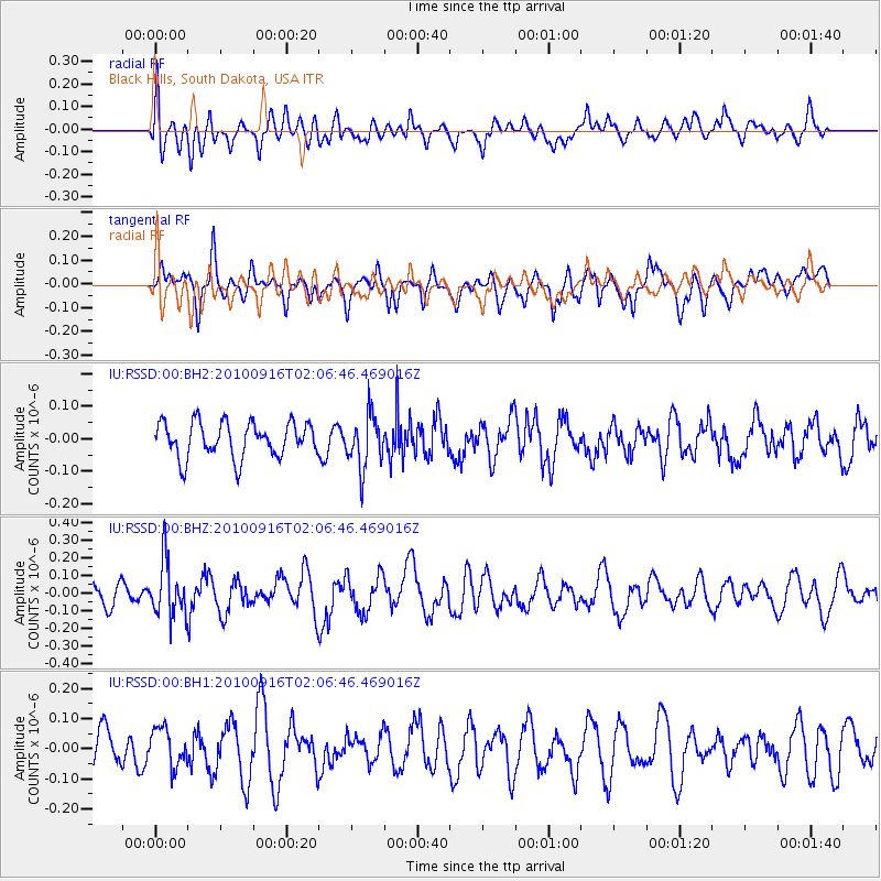
RSSD Black Hills, South Dakota, USA - Earthquake Result Viewer
*The percent match for this event was below the threshold and hence no stack was calculated.
| Earthquake location: |
Tonga Islands |
| Earthquake latitude/longitude: |
-16.0/-174.0 |
| Earthquake time(UTC): |
2010/09/16 (259) 01:54:40 GMT |
| Earthquake Depth: |
84 km |
| Earthquake Magnitude: |
5.5 MB, 5.8 MW, 5.8 MW |
| Earthquake Catalog/Contributor: |
WHDF/NEIC |
|
| Network: |
IU Global Seismograph Network (GSN - IRIS/USGS) |
| Station: |
RSSD Black Hills, South Dakota, USA |
| Lat/Lon: |
44.12 N/104.04 W |
| Elevation: |
2090 m |
|
| Distance: |
87.3 deg |
| Az: |
42.625 deg |
| Baz: |
244.714 deg |
| Ray Param: |
$rayparam |
*The percent match for this event was below the threshold and hence was not used in the summary stack. |
|
| Radial Match: |
42.324745 % |
| Radial Bump: |
400 |
| Transverse Match: |
51.604607 % |
| Transverse Bump: |
374 |
| SOD ConfigId: |
617450 |
| Insert Time: |
2013-10-01 11:40:09.491 +0000 |
| GWidth: |
2.5 |
| Max Bumps: |
400 |
| Tol: |
0.001 |
|
Signal To Noise
| Channel | StoN | STA | LTA |
| IU:RSSD:00:BHZ:20100916T02:06:46.469016Z | 2.9800942 | 1.5855466E-7 | 5.320458E-8 |
| IU:RSSD:00:BH1:20100916T02:06:46.469016Z | 1.2290652 | 6.415873E-8 | 5.2201244E-8 |
| IU:RSSD:00:BH2:20100916T02:06:46.469016Z | 1.5255084 | 8.1915076E-8 | 5.3696905E-8 |
| Arrivals |
| Ps | |
| PpPs | |
| PsPs/PpSs | |


