You are here: Home > Network List > IU - Global Seismograph Network (GSN - IRIS/USGS) Stations List
> Station RSSD Black Hills, South Dakota, USA > Earthquake Result Viewer
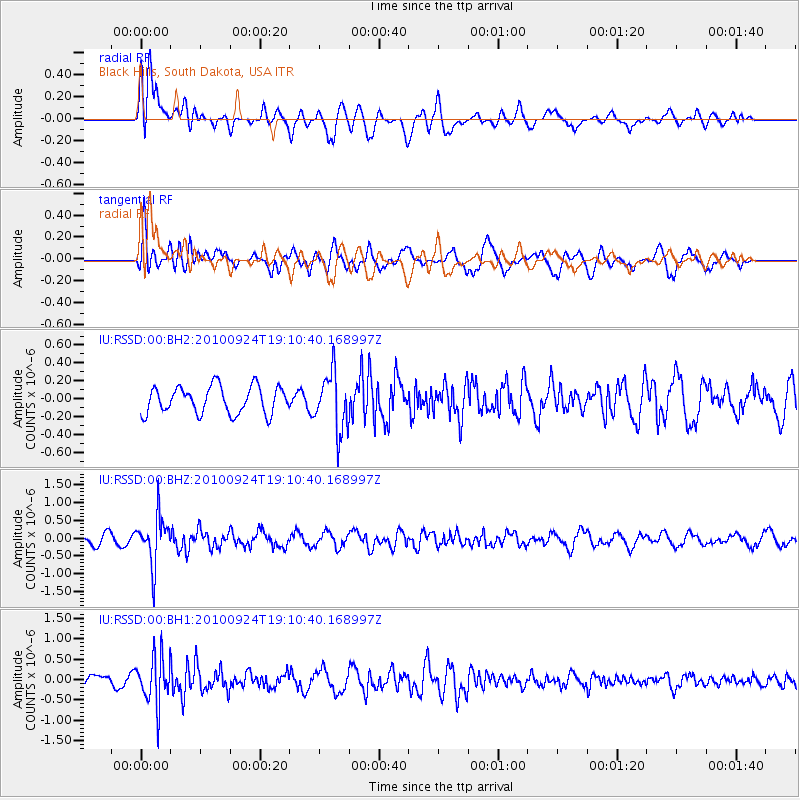
RSSD Black Hills, South Dakota, USA - Earthquake Result Viewer
*The percent match for this event was below the threshold and hence no stack was calculated.
| Earthquake location: |
Peru-Brazil Border Region |
| Earthquake latitude/longitude: |
-7.8/-74.4 |
| Earthquake time(UTC): |
2010/09/24 (267) 19:01:32 GMT |
| Earthquake Depth: |
150 km |
| Earthquake Magnitude: |
5.5 MW, 5.5 MW, 5.7 MB |
| Earthquake Catalog/Contributor: |
NEIC PDE/NEIC PDE-M |
|
| Network: |
IU Global Seismograph Network (GSN - IRIS/USGS) |
| Station: |
RSSD Black Hills, South Dakota, USA |
| Lat/Lon: |
44.12 N/104.04 W |
| Elevation: |
2090 m |
|
| Distance: |
58.2 deg |
| Az: |
335.215 deg |
| Baz: |
144.777 deg |
| Ray Param: |
$rayparam |
*The percent match for this event was below the threshold and hence was not used in the summary stack. |
|
| Radial Match: |
60.648273 % |
| Radial Bump: |
400 |
| Transverse Match: |
76.10961 % |
| Transverse Bump: |
400 |
| SOD ConfigId: |
617450 |
| Insert Time: |
2013-10-01 11:49:00.305 +0000 |
| GWidth: |
2.5 |
| Max Bumps: |
400 |
| Tol: |
0.001 |
|
Signal To Noise
| Channel | StoN | STA | LTA |
| IU:RSSD:00:BHZ:20100924T19:10:40.168997Z | 4.804298 | 6.802113E-7 | 1.4158391E-7 |
| IU:RSSD:00:BH1:20100924T19:10:40.168997Z | 3.4890177 | 5.974626E-7 | 1.7124093E-7 |
| IU:RSSD:00:BH2:20100924T19:10:40.168997Z | 2.1002216 | 3.169756E-7 | 1.5092483E-7 |
| Arrivals |
| Ps | |
| PpPs | |
| PsPs/PpSs | |


