You are here: Home > Network List > II - Global Seismograph Network (GSN - IRIS/IDA) Stations List
> Station PFO Pinon Flat, California, USA > Earthquake Result Viewer
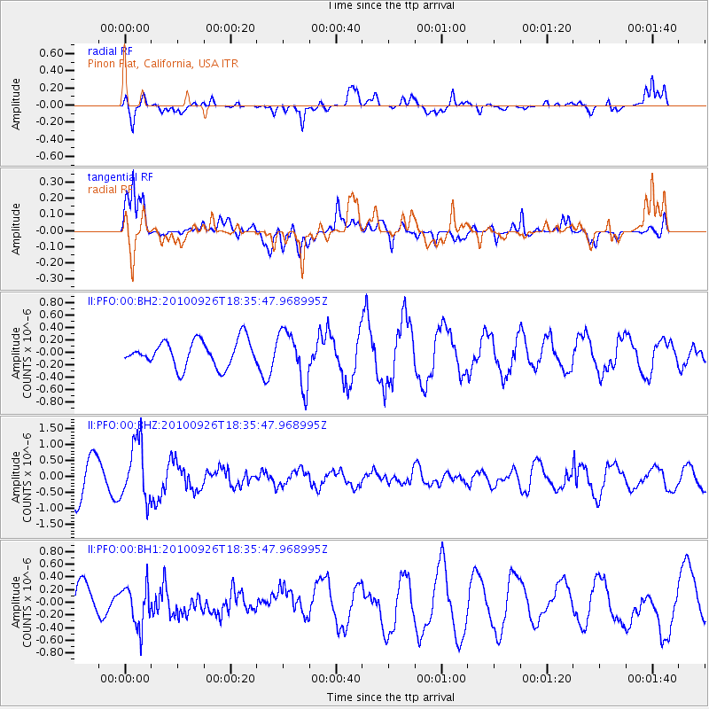
PFO Pinon Flat, California, USA - Earthquake Result Viewer
*The percent match for this event was below the threshold and hence no stack was calculated.
| Earthquake location: |
Rat Islands, Aleutian Islands |
| Earthquake latitude/longitude: |
52.4/179.7 |
| Earthquake time(UTC): |
2010/09/26 (269) 18:27:57 GMT |
| Earthquake Depth: |
226 km |
| Earthquake Magnitude: |
5.8 MW, 5.5 MB, 5.8 MW |
| Earthquake Catalog/Contributor: |
NEIC PDE/NEIC PDE-M |
|
| Network: |
II Global Seismograph Network (GSN - IRIS/IDA) |
| Station: |
PFO Pinon Flat, California, USA |
| Lat/Lon: |
33.61 N/116.46 W |
| Elevation: |
1280 m |
|
| Distance: |
48.6 deg |
| Az: |
86.478 deg |
| Baz: |
312.929 deg |
| Ray Param: |
$rayparam |
*The percent match for this event was below the threshold and hence was not used in the summary stack. |
|
| Radial Match: |
67.02729 % |
| Radial Bump: |
400 |
| Transverse Match: |
78.10006 % |
| Transverse Bump: |
400 |
| SOD ConfigId: |
617450 |
| Insert Time: |
2013-10-01 11:56:25.318 +0000 |
| GWidth: |
2.5 |
| Max Bumps: |
400 |
| Tol: |
0.001 |
|
Signal To Noise
| Channel | StoN | STA | LTA |
| II:PFO:00:BHZ:20100926T18:35:47.968995Z | 1.889282 | 9.071016E-7 | 4.801304E-7 |
| II:PFO:00:BH1:20100926T18:35:47.968995Z | 1.2981344 | 3.2750208E-7 | 2.5228672E-7 |
| II:PFO:00:BH2:20100926T18:35:47.968995Z | 2.0651038 | 4.3379E-7 | 2.1005725E-7 |
| Arrivals |
| Ps | |
| PpPs | |
| PsPs/PpSs | |


